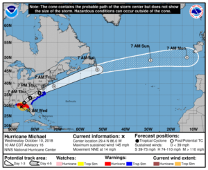
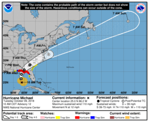
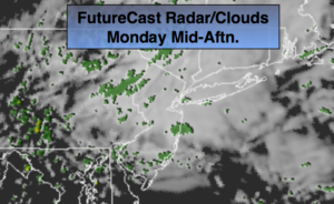
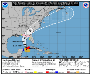
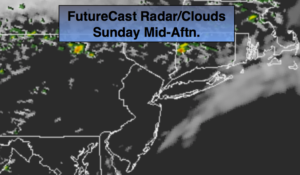
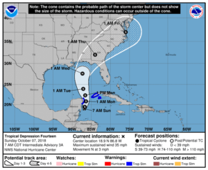
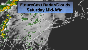
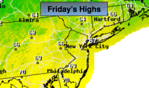
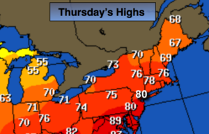
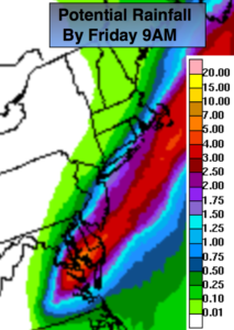
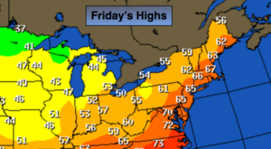
AM Rain to Scattered PM Showers…Decent Weekend…


Synopsis:

A weak low will rapidly move up the coast today with a period of rain this morning into midday. There maybe some afternoon sun in spots between spotty showers as the low pulls away. It’ll be cooler than average.

The weekend looks fairly decent. A mix of sun and clouds is expected Saturday. As a cold front will approaches in the afternoon, spotty showers are possible. Sunday will be bright and cool with readings several degrees below average. The average high this time of the year is in the mid 60s.

Much warmer weather is in store next week. In fact, it’ll feel like Summer by Wednesday.

Stay tuned.

Today:

Mostly cloudy with a period of rain. Some Afternoon sun is possible along with an isolated showers. Highs in the upper 50s to around 60º. Northeast winds at 5-10mph.

Tonight:

Becoming partly cloudy. Lows in the lower 50s in the City, the 40s inland. Winds Northwest becoming West less than 5mph.

Saturday:

Partly sunny. Spotty late afternoon showers. Highs in the mid to upper 60s.

Sunday:

Partly sunny, cooler . Highs in the mid to upper 50s.

Monday:

Mostly sunny, cool. Highs in the lower 60s.

Tuesday:

Sunny. Much Warmer. Highs in the mid 70s.

Keep it here for a no nonsense, no hype forecast.


A Gem Today. Sunny and Mild. Another Round of Rain for Friday…


Synopsis:

The low responsible for the rain yesterday will pull into Northern New England today and allow for drier air to work. It’ll be mostly sunny and mild.

A weak low will rapidly move up the coast on Friday with a period of rain.

The weekend looks fairly decent. A mix of sun and clouds is expected Saturday. As a cold front will approaches in the afternoon, spotty showers are possible. Sunday will be bright and cool with readings several degrees below average. The average high this time of the year is in the mid 60s.

Much warmer weather is in store next week. In fact, it’ll feel like Summer by Wednesday.

Stay tuned.

Today:

Mostly sunny. Mild. Highs in the upper 60s. West winds at 10-15mph.

Tonight:

Clear early becoming mostly cloudy late. Lows in the lower 50s in the City, the 40s inland. Winds Northwest becoming East less than 5mph.

Friday:

Mostly cloudy with a period of rain. Highs in the lower 60s.

Saturday:

Partly sunny. Spotty afternoon showers. Highs in the mid 60s.

Sunday:

Partly sunny, cooler . Highs in the upper 50s.

Monday:

Mostly sunny, seasonal. Highs in the mid 60s.

Keep it here for a no nonsense, no hype forecast.


Periods of AM Rain. Spotty Shower This Afternoon…


Synopsis:

An area of low pressure will work up from the South today. The steadiest and heaviest rain looks to be in the morning. There will most likely be a break in the rain during the afternoon. Some brightening of the skies are possible, especially West of the City. Another batch of showers will work through this evening as the front moves through.

We’ll dry out Thursday with the sun returning. A weak low will rapidly move up the coast on Friday with scattered showers.

A decent weekend looks to be shaping up with a mix of sun and clouds and seasonal readings.

Stay tuned.

Today:

Periods of rain this morning. Mostly cloudy this afternoon with a spot shower. Highs in the upper 50s. Northeast winds diminishing to 5-10mph by afternoon.

Tonight:

Scattered showers. Lows in the upper 40s to lower 50s. Winds becoming West at 5-10mph.

Thursday:

Clouds and sun. Highs in the upper 60s.

Friday:

Mostly cloudy with scattered showers. Highs in the lower 60s.

Saturday:

Partly sunny. Highs in the mid 60s.

Sunday:

Partly sunny, cooler . Highs around 60º.

Keep it here for a no nonsense, no hype forecast.


A Monday Gem…


Synopsis:

The week will start off just like the weekend ended-beautiful. Highs will be above average by a few degrees with wall to wall sunshine today. The high will slip off the coast on Tuesday and allow an area of low pressure to work up the coast. Sun will give way to clouds.

Wednesday will be wet at the low moves over the area with periods of rain.

Drier conditions are expected for the end of the week with seasonal readings. We’ve finally turned the corner!

Stay tuned.

Today:

Sunny. Highs in the mid to upper 60s. East to Southeast winds at 5-10mph.

Tonight:

Clear to partly cloudy. Lows in the mid to upper 40s in the City, the 30’s inland. Southeast winds less than 5mph.

Tuesday:

Any early sun will give way to increasing clouds. Highs around 60º.

Wednesday:

Periods of rain. Highs in the mid to upper 50s.

Thursday:

Clouds and sun. Highs in the lower 60s.

Friday:

Partly sunny. Highs in the lower 60s.

Keep it here for a no nonsense, no hype forecast.


Spring Sunday Winner…


Synopsis:

It’ll be a top ten Spring day today. High pressure over the area will result in sunny skies and near average temperatures for the date. The average high is in the lower to mid 60s. Winds will be light.

The week will start off just like the weekend ended-beautiful. The high will slip off the coast on Tuesday and allow an area of low pressure to work up the coast. Sun will give way to clouds.

Wednesday will be wet at the low moves over the area with periods of rain.

Drier conditions are expected for the end of the week with seasonal readings. We’ve finally turned the corner!

Stay tuned.

Today:

Sunny. Highs in the mid 60s. Northwest to Southwest winds at 5-10mph.

Tonight:

Clear. Lows in the mid 40s in the City, the 30’s inland. Southwest winds to North under 5mph.

Monday:

Sunny. Highs in the mid 60s.

Tuesday:

Sun will give way to increasing clouds. Highs around 60º.

Wednesday:

Rain likely. Some late day sun is possible. Highs in the mid to upper 50s.

Thursday:

Clouds and sun. Highs in the lower 60s.

Keep it here for a no nonsense, no hype forecast.


Decent Weekend. Plenty of Sun…


Synopsis:

The weekend looks mainly sunny and cool as high pressure works in. Readings will be below average by a few degrees. The average high is 63º for the date. Hey, anything is better than snow and cold winds.

It looks like below average temperatures will continue for some time as the Northern branch of the jet stream remains close to our latitude. We’ll also be watching a storm along the Southeast coast and it’s affects on our area midweek. There’s a decent chance of rain Wednesday.

Stay tuned.

Today:

Mostly sunny. Highs in the mid to upper 50s. Northwest winds at 5-10mph.

Tonight:

Clear. Lows in the lower 40s in the City,near freezing inland. Northwest winds under 5mph.

Sunday:

Sunny. Highs around 60º.

Monday:

Sunny. Highs in the lower 60s.

Tuesday:

Sun will give way to increasing clouds. Highs around 60º.

Wednesday:

Rain likely. Highs around 50º.

Keep it here for a no nonsense, no hype forecast.


Windy & Chilly Friday. Decent Weekend. Plenty of Sun…


Synopsis:

The sun will return today, but it will be windy and chilly as low pressure over Eastern Canada continues to influence our weather. The weekend looks mainly sunny and cool and high pressure works in. Readings will be below average by a few degrees. The average high is 63º for the date.

It looks like below average temperatures will continue for some time as the Northern branch of the jet stream remains close to our latitude. We’ll also be watching a storm off the Southeast coast and it’s possible affects on our area midweek.  Yep, this Spring is tough to take.

Stay tuned.

Today:

Partly sunny. Windy. Highs around 50º. Northwest winds at 15-25mph with gusts to 30mph.

Tonight:

Clear and cold. Lows in the upper 30s in the City,near 30º inland. Northwest winds diminishing to 5-10mph.

Saturday:

Mostly sunny. Highs in the mid to upper 50s.

Sunday:

Sunny. Highs in the upper 50s.

Monday:

Mostly sunny. Highs in the lower 60s.

Tuesday:

Sun will give way to increasing clouds. Highs in the lower 60s.

Keep it here for a no nonsense, no hype forecast.


Spot Shower This Evening. Another Cold Night. Windy/Chilly Friday…


Synopsis:

Any spotty showers will end this evening, otherwise it’ll become partly cloudy and windy. Readings will be well below average with wind chills well below freezing as a storm moves to Eastern Canada.

The sun will once again return Friday but it will be windy and chilly. The weekend looks mainly sunny and cool and high pressure works in.

It looks like below average temperatures will continue for some time as the Northern branch of the jet stream remains close to our latitude. We’ll also be watching a storm off the Southeast coast and it’s possible affects on our area midweek.  Yep, this Spring is tough to take.

Stay tuned.

Tonight:

Spotty early evening showers, otherwise, becoming partly cloudy. Cold. Lows in the 30s throughout. Windy. Northwest winds at 15-30mph. Wind chills in the 20s to around freezing.

Friday:

Partly sunny. Windy. Highs around 50º. Northwest winds at 15-25mph with gusts to 30mph.

Saturday:

Mostly sunny. Highs in the mid to upper 50s.

Sunday:

Sunny. Highs in the upper 50s.

Monday:

Mostly sunny. Highs in the lower 60s.

Tuesday:

Sun will give way to increasing clouds. Highs in the lower 60s.

Keep it here for a no nonsense, no hype forecast.


Scattered Showers Today. Chilly…


Synopsis:

A rapidly moving low pressure will move off the New England coast later this afternoon and move out to sea. There will be two batches of showers. One early this morning with the low over the region; the other this afternoon with the passage of the cold front. It will feel more like early March than mid April. In fact, don’t be surprised if a few flakes fly mainly North of the City today.

The sun will once again return Friday but it will be windy and chilly. The weekend looks mainly sunny and cool and high pressure works in.

It looks like below average temperatures will continue for some time as the Northern branch of the jet stream remains close to our latitude. We’ll also be watching a storm off the Southeast coast.  Yep, this Spring is tough to take.

Stay tuned.

Today:

Mostly cloudy. Rain early this morning, then remain mainly cloudy with scattered showers this afternoon. Highs in the 40s to around 50º. Becoming breezy later in the afternoon. Northeast to Northwest winds increasing to 10-20mph later in the day.

Tonight:

Spotty early evening showers, otherwise, becoming partly cloudy. Cold. Lows in the 30s throughout. Windy. Northwest winds at 15-30mph.

Friday:

Partly sunny. Windy. Highs around 50º.

Saturday:

Mostly sunny. Highs in the mid 50s.

Sunday:

Sunny. Highs in the upper 50s.

Monday:

Mostly sunny. Highs around 60º.

Keep it here for a no nonsense, no hype forecast.


Better Feel Today. Sun & Clouds…


Synopsis:

The sun will return today as the area is in between systems. A rapidly moving low pressure will move through later tonight and Thursday with another round of spotty showers. The sun will once again return Friday but it will be windy and chilly. The weekend looks mainly sunny and cool and high pressure works in.

It looks like below average temperatures will continue for some time as the Northern branch of the jet stream remains close to our latitude. Yep, this Spring is tough to take.

Stay tuned.

Today:

Becoming mostly sunny. Highs in mid to upper 50s. West winds at 10-15mph with gusts to 25mph.

Tonight:

Increasing clouds. Light rain likely after midnight for a few hours. Lows in the mid 40s in the City, near 40º inland. West winds becoming Southeast at 5mph.

Thursday:

Mostly cloudy. Chance of showers. Highs in lower to mid 50s.

Friday:

Partly sunny. Windy. Highs around 50º.

Saturday:

Mostly sunny. Highs in the mid 50s.

Sunday:

Mostly sunny. Highs in the upper 50s.

Keep it here for a no nonsense, no hype forecast.