Synopsis:
Hurricane Michael made landfall yesterday afternoon just short of category 5 status (winds of 155mph) near Mexico Beach, Florida. Catastrophic damage has occurred. This was the strongest hurricane to hit the Florida panhandle since records have been kept. It’s also the 4th strongest hurricane in terms of sustained wind to hit the US and the 3rd most intense relating to low barometric pressure. Michael has weakened to a tropical storm will move through the Carolinas today and off the Virginia coast tonight.
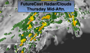
A cold font will be approaching the region later today. On and off showers and thunderstorms are likely. Some of the rain maybe torrential at times. The front will draw up some tropical moisture from Michael as it moves off the Mid-Atlantic coast tonight. The storm will miss the area but the combination of both factors mentioned above has prompted a Flash Flood Watch for much of the tri-state area later Thursday and Thursday night. The heaviest rain will fall along the Southern NJ coast. The rain taper off very early Friday morning with Eastern Long Island being the last to dry out by mid-morning. The sun will return Friday along with much cooler and less humid conditions.
The weekend will be chilly with readings actually below average for a change. A few shower are possible Saturday. Sunday will be the better half of the weekend with plenty of sun.
You know where to find a no hype, no nonsense forecast.
Stay tuned.
Today:
Cloudy with on and off showers and storms. Local downpours. Humid. Highs in the mid 70s. South to Southwest winds at 5-10mph.
Tonight:
Scattered showers with an isolated storm. Heaviest rain will fall over coastal NJ. Much cooler and less humid by morning. Lows in the upper 50s in the City, the lower to mid 50s inland. Southwest to Northwest wind increasing to 15-25mph late.
Friday:
Early morning rain possible at the coast, otherwise becoming mostly sunny. Much cooler, breezy and less humid. Highs in the mid 60s.
Saturday:
Becoming mostly cloudy. Showers possible. Very cool Highs in the upper 50s.
Sunday:
Mostly sunny & cool. Highs in the lower 60s.
Monday:
Early sun to afternoon showers. Highs in the mid 60s.
Keep it here for a no nonsense, no hype forecast.