
Synopsis:
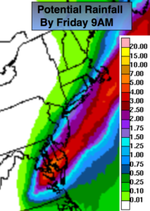
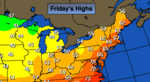
Tropical Storm Michael will move off the Virginia coast tonight at the same time a cold front will be moving through. On and off showers and thunderstorms are likely. Some of the rain maybe torrential at times. The front will draw up some tropical moisture from Michael as it moves off the Mid-Atlantic coast tonight. Micheal will miss the area but the combination of both factors mentioned above has prompted a Flash Flood Watch for much of the region through late tonight. One to three inches of rain is possible. The heaviest rain will fall along the Southern NJ coast & Eastern Long Island (1st map above). The rain taper off very early Friday morning with Eastern Long Island being the last to dry out by mid-morning. The sun will return Friday along with much cooler and less humid conditions. Temperatures will finally be near the average high of 66º.
The weekend will be chilly with readings actually below average for a change. A few showers are possible Saturday morning with the sun returning during the afternoon. Sunday will be the better half of the weekend with plenty of sun as high pressure dominates.
You know where to find a no hype, no nonsense forecast.
Stay tuned.
Tonight:
Scattered showers with an isolated storm. Torrential rain at times. The heaviest rain will fall over coastal NJ later tonight. Much cooler and less humid by morning. Lows in the upper 50s in the City, the lower to mid 50s inland. Southwest to Northwest wind increasing to 15-25mph late.
Friday:
Early morning rain possible at the coast, otherwise becoming mostly sunny. Much cooler, breezy and less humid. Highs in the mid 60s.
Saturday:
Showers possible during the morning, otherwise becoming partly sunny. Very cool. Highs in the upper 50s.
Sunday:
Mostly sunny & cool. Highs around 60º.
Monday:
Early sun to afternoon showers. Highs in the mid 60s.
Tuesday:
Partly sunny, chilly. Highs in the upper 50s.
Keep it here for a no nonsense, no hype forecast.