Synopsis:
A front moving through this evening will spark a scattered shower or storm. The front will be significant and bring down temperatures to more seasonal levels Friday and Saturday. It’ll finally feel like Fall as high pressure over Eastern Canada dominates.
The high pressure will move over the region and offshore Sunday. Temperatures will pop once again to well above the average highs as winds begin to turn to a Southerly direction. This high looks to park itself over the Eastern Seaboard into next week resulting in above average temperatures and dry conditions.
You know where to find a no hype, no nonsense forecast.
Stay tuned.
Tonight:
An evening shower or thunderstorm, otherwise becoming mostly clear and cool. Lows near 60º in the City, the upper 40s to 50s inland. Southwest to North wind at 8-12mph.
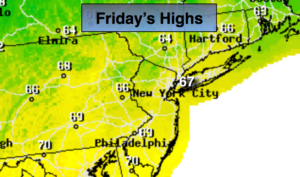
Friday:
Mostly sunny, much cooler and less humid. Highs in the upper 60s (which is actually the average highs for this time of the year).
Saturday:
Mostly sunny. Highs in the upper 60s.
Sunday:
Mostly sunny, much warmer. Highs in the upper 70s.
Monday:
Mostly sunny. Warm. Highs in the upper 70s.
Tuesday:
Mostly sunny. Warm. Highs in the upper 70s.
Keep it here for a no nonsense, no hype forecast.