Synopsis:
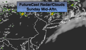
High pressure off the Northeast coast will result in a wind off the ocean into this morning. Moisture will be trapped at the lowest level of the atmosphere and will cause clouds to dominate through the morning hours with patchy drizzle possible.
The high pressure will move farther offshore by midday and during the afternoon. Temperatures will pop once again to well above the average highs as winds begin to turn to a Southwesterly direction. Clouds will give way to some sun by afternoon. A spot late or evening storm can’t be ruled out as the atmosphere becomes unstable.
Another high will move toward Northern New England on Monday-Columbus Day. This will once again result in a flow off the ocean. Columbus Day will be mainly grey with spotty showers or areas of drizzle possible.
This high looks to park itself over the off the Eastern Seaboard Tuesday and Wednesday resulting in above average temperatures and dry conditions.
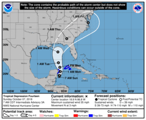
By late week a tropical system will most likely come out of the Gulf of Mexico. Will it go off the Southeast coast or ride up the piedmont and affect our weather as a decaying storm. It’s still early to give an answer, but be aware that a round of heavy rain and gusty winds is possible if track is close enough to the tri-state area.
You know where to find a no hype, no nonsense forecast.
Stay tuned.
Today:
Morning clouds and patchy drizzle will give way to a mix of clouds and sun; it’ll be much warmer and humid. A spot shower or storm is possible late day and or during the evening. Highs around 80º. Southwest winds at 5-10mph.
Tonight:
Mostly cloudy with areas of drizzle. Lows in the mid 60s in the City, around 60º inland. Southeast to South winds at 5mph.
Monday:
Mostly cloudy with scattered showers or areas of drizzle possible. Highs in the lower to mid 70s.
Tuesday:
Clouds to some sun. Warm. Highs near 80º.
Wednesday:
Mostly sunny. Warm. Highs near 80º.
Thursday:
Mostly cloudy with scattered showers and storms likely. Humid. Highs in the mid 70s.
Keep it here for a no nonsense, no hype forecast.