Synopsis:
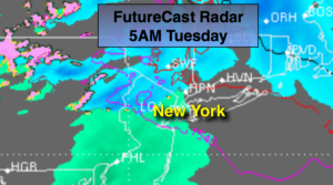
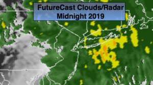
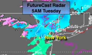
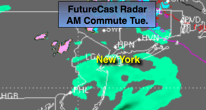
A weak low pressure system will approach tonight. Scattered snow showers are possible later this afternoon into the evening. Overnight scattered areas of light snow, mix and rain is likely depending on your location (first map above). This shouldn’t be a big deal. A light coating of slushy snow is possible North and West by sunrise. Mild air will work in and change any leftover precipitation to light rain during the morning commute (2nd map above).
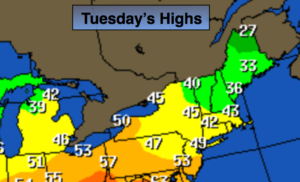
Tuesday we’ll be sandwiched between the departing weak low and another weak low heading our way from the West. Skies will remain cloudy and it’ll be mild. Another shot of scattered rain and or snow showers is possible with the a second low moving into New England Tuesday night. This low will be followed by typical January readings as the flow will come out of Canada. Highs for late week will be below average for a change. The average high is 38º.
There has been chatter about a possible storm on Sunday. Some of the models taken verbatim give parts of the area a snowstorm, while other models like the European have a weak system offshore with little if any snowfall. This is 5 days away. Plenty can change, but at this time I’m leaning with the European. Please continue to check back to JMW for the very latest.
You know where to find a no hype, no nonsense forecast.
Stay tuned.
Tonight:
Cloudy with scattered snow and rain showers. A bit of Freezing rain or sleet may fall North and West. Temperatures will rise through the 20s inland, the 30s at the coast. Southeast winds diminishing 5mph.
Tuesday:
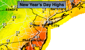
Morning showers, otherwise, cloudy and mild. Highs around 50º. Southeast to South winds at 5mph.
Wednesday:
Partly sunny. Highs in the mid 40s.
Thursday:
Partly sunny. Cold. Highs in the mid 30s.
Friday:
Partly sunny. Cold. Highs around freezing.
Saturday:
Sun to afternoon clouds. Cold. Highs around freezing.