Synopsis:
High pressure moving off the coast through today will provide the region with mild temperatures and a mix of sun and clouds.
A low will be just to our South on Saturday morning. The low will move off the NJ coast and to near Cape Cod by evening with on and off rain. Partly sunny skies are expected for Sunday with breezy conditions.
A weak low pressure system will approach Monday night and Tuesday morning with a bit of rain and or wet snow.
The strong Pacific jet stream continues to dominate. This pattern of no intrusion of Arctic air looks to continue for the first ten days of January. Sorry snow lovers, the wait continues for a substantial snowfall.
You know where to find a no hype, no nonsense forecast.
Stay tuned.
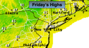
Today:
Sun for the early morning hours. High clouds will work in during the day. Highs in the upper 40s. Southwest winds at 5-10mph.
Tonight:
Thickening clouds. Rain will move in toward midnight. Lows in the 40s in the City, the 30s inland. South to Northeast winds at 5-10mph.
Saturday:
On and off rain. Highs in the mid to upper 40s.
Sunday:
Partly sunny. Highs in the mid 40s.
Monday:
Partly sunny, seasonal. Highs in the upper 30s.
Tuesday:
Early morning rain, a mix inland. Afternoon sun. Highs in the upper 40s.
Keep it here for a no nonsense, no hype forecast.