Synopsis:
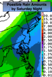
Low pressure developing over the central Appalachians tonight will bring rain into the region around midnight. The low will move off the NJ coast and to near Cape Cod by Saturday evening with on and off rain. Most areas will receive close to an inch of rain (map above) something we don’t need. Please use caution traveling. Urban street and highway flooding is possible.
Partly sunny skies are expected for Sunday along with breezy to windy conditions. Readings will still be a few degrees above the average high of the upper 30s.
A weak low pressure system will approach Monday night. Light rain or snow showers are possible. This shouldn’t be a big deal.
The strong Pacific jet stream continues to dominate. This pattern of no intrusion of Arctic air looks to continue for the first ten days of January. It may cool down some midweek next week but it won’t be frigid. Sorry snow lovers, the wait continues for a substantial snowfall.
You know where to find a no hype, no nonsense forecast.
Stay tuned.
Tonight:
Thickening clouds. Rain will move in toward midnight. Steady temperatures. Lows in the 40s in the City, the 30s inland. South to Northeast winds at 5-10mph.
Saturday:
On and off rain. Highs in the mid to upper 40s. Northeast to North wind at 10-20mph.
Sunday:
Partly sunny and breezy. Highs in the mid 40s.
Monday:
Partly sunny, seasonal. Highs in the upper 30s.
Tuesday:
Morning clouds. Afternoon sun. Mild. Highs in the upper 40s to around 50º.
Keep it here for a no nonsense, no hype forecast.