Synopsis:
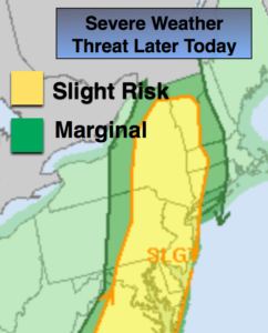
A weak stationary front will be over the area today. It’ll be partly sunny and humid. A stray afternoon shower can’t be ruled out.
The front will begin to dissolve over the region and the end of the week and into the weekend is looking nice. It will be warming up and by Sunday August’s heat will be back. Spotty afternoon storms can’t be ruled out but much of the time will be dry under hazy sun.
Keep it here for a no nonsense, no hype forecast.
Today:
Clouds and sun. Stray afternoon showers. Highs in the lower 80s. Northeast to East winds at 5-10mph.
Tonight:
An isolated shower this evening otherwise partly cloudy. Lows in the 60s to around 70º. East to Northeast winds at 5mph.
Friday:
Partly sunny. Highs in the lower 80s.
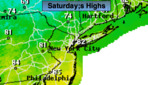
Saturday:
Partly sunny. Scattered afternoon storms. Highs mid 80s.
Sunday:
Hazy, hot and humid. Highs near 90º.
Monday:
Hazy, hot and humid. Highs near 90º.