Synopsis:
A cool front will approach today along with low pressure. Hazy, warm and humid conditions are back with us. Scattered showers will move through this morning. The threat of thunderstorms continues for later today and this evening but the greatest chance now appears to be South of the City. The main energy with the system has shifted farther to the South. Areas to the North will most likely not get into the action.
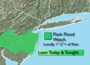
Flash flooding may also be of concern for Central and Southern NJ. A Flash Flood watch is up for this area (1st map above). Never drive through flooded roadways, you don’t know how deep the water is. TURN AROUND, DON’T DROWN.
The system will move slowly off the coast on Wednesday. A few showers are possible, especially in the morning, otherwise a mix of clouds and sun is expected.
A slight chance of showers exists for Thursday but the majority of the day will be dry. The end of the week and into the weekend is looking nice with near seasonal temperatures.
Keep it here for a no nonsense, no hype forecast.
Today:
Hazy, warm and humid. Scattered showers are possible just about anytime. Scattered thunderstorms are likely mainly South of the City this afternoon and evening. Highs in the lower to mid 80s. Southwest to West winds at 5-10mph.
Tonight:
Scattered showers and thunderstorms (mainly South), otherwise cloudy and muggy. Lows in the 60s throughout. Winds becoming North at 5mph.
Wednesday:
Clouds and sun. stray showers. Highs in the lower 80s.
Thursday:
Partly sunny. Stray showers. Highs in the lower 80s.
Friday:
Mostly sunny. Highs in the lower to mid 80s.
Saturday:
Mostly sunny. Highs in the lower to mid 80s.