Synopsis:
This maybe one of the best August weekends we’ve experienced in some time. High pressure will dominate the Mid-Atlantic and Northeast. Abundant sunshine and low humidity is expected! Temperatures will actually be below the average high of 83º. Overnight lows will be almost fall-like.
On Monday, the high will slip offshore. A Southerly flow will develop. Temperatures and humidity will come up.
On Tuesday, a cool front will approach. Scattered showers and storms are expected.
Keep it here for a no nonsense, no hype forecast.
Today:
Mostly sunny and comfortable. A top ten day. Highs in the lower 80s. West to Northwest winds at 10-20mph.
Tonight:
Clear and cool. Lows in the 60s in urban areas, the 50s inland. Northwest winds at 5-10mph.
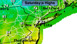
Sunday:
Sunny and comfortable. Another top ten day. Highs in the lower 80s.
Monday:
Mostly sunny. More humid. Highs in the mid 80s.
Tuesday:
Hazy, warm and humid. Scattered showers and storms. Highs in the mid 80s.
Wednesday:
Clouds and sun. Scattered showers. Highs in the mid 80s.