Synopsis:
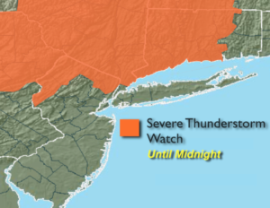
*** A Severe Thunderstorm Watch is in effect until Midnight for areas North of NYC (see 1st map above). A cool front will approach this evening. Moisture is limited although an isolated storm can’t be ruled out during the evening hours. Some of the storms maybe strong to isolated severe especially North. Skies will be partly cloudy overnight with lowering levels of humidity.
Friday will be mostly sunny and comfortable as humidity levels will be low. A picture perfect finish to the week.
This maybe one of the best August weekends we’ve experienced in some time. High pressure will dominate the Mid-Atlantic and Northeast. Abundant sunshine and low humidity is expected!
Keep it here for a no nonsense, no hype forecast.
Tonight:
Spotty isolated storms, otherwise partly cloudy and less humid. Lows around 70º in urban areas, near 60º well inland. West to Northwest winds at 5-10mph.
Friday:
Mostly sunny. Much lower humidity. Highs in the mid 80s.
Saturday:
Sunny and comfortable. A top ten day. Highs in the lower 80s.
Sunday:
Sunny and comfortable. Another top ten day. Highs in the lower to mid 80s.
Monday:
Mostly sunny. Highs in the mid 80s.
Tuesday:
Hazy, warm and humid. Spotty PM Storms. Highs in the mid 80s.