Synopsis:
Today’s weather map will feature a cool front approaching. Ahead of the front it will be warm and humid. Morning clouds, areas of fog and drizzle with give way to some hazy sun by afternoon. It will have a tropical feel. Scattered showers and spotty storms are possible from mid afternoon through early evening.
Spotty showers and storms will continue into early tonight. It will be muggy.
The front will be slow to exit resulting in a morning clouds and possible showers over Eastern areas on Saturday. The system will push East and the sun will return during the morning. It will be much less humid. Sunday-May’s Finale will be sunny and cooler as high pressure influences the region from Canada. June arrives on Monday with cooler than average temperatures under a mix of sun and clouds.
Temperatures will be below normal heading into next week. It will be pleasant.
Stay Tuned.
Keep it here for a no nonsense, no hype forecast.
Today:
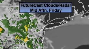
Areas of morning fog and drizzle, otherwise hazy, warm and humid. Mid-afternoon and evening scattered showers and possible storms. Highs in the lower to mid 80s away from the coast. The 70s closer to the ocean. South winds at 8-12mph.
Tonight:
Scattered showers and storm. Warm and muggy. Lows in the mid to upper 60s. Southwest winds less than 5mph.
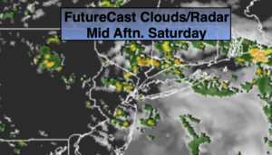
Saturday:
Morning clouds and showers East, otherwise beaconing mostly sunny. Much less humid. Highs around 80º.
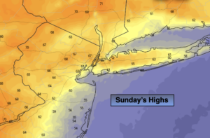
Sunday:
Sunny and cooler. Highs around 70º.
Monday:
Partly sunny. Cool. Highs in the upper 60s.
Tuesday:
Partly sunny. Highs in the lower 70s.