Synopsis:
The sun will greet us through late afternoon and evening as the front that gave parts of the area some strong storms moves offshore. The wind will pick up dramatically around sunset.
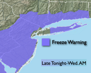
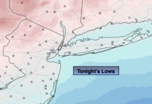
Tonight will be clear, windy and cold. A Freeze Warning is in effect for the area excluding New York City. Wind chills will be in the 20s.
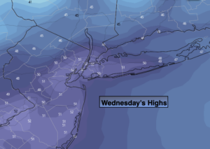
Wednesday will be blustery and chilly under mostly sunny skies as the flow will continue out of Canada.
A storm will develop over the Ohio Valley on Thursday. Any sun will give way to clouds and an increasing chance of rain through the afternoon. Friday will be wet as the low passes through the region.
Hopefully, we’ll squeeze out a dry Saturday as we’ll be in between systems.
A Sunday spoiler is on the way with more rain in the forecast. Spring can be a rough season, especially early on.
Stay Tuned.
Keep it here for a no nonsense, no hype forecast.
Tonight:
Mostly clear, windy and cold. Lows in the mid 30s in the City, the 20s to around freezing in the ‘burbs. West to Northwest winds at 15-30mph with gusts to 40mph early.
Wednesday:
Mostly sunny, breezy and chilly. Highs only in the lower 50s. West winds at 15-25mph with gusts to 30mph.
Thursday:
Morning sun, otherwise increasing clouds with a chance of late day rain. Highs in the lower to mid 50s.
Friday:
Rain likely. Highs in the lower to mid 50s.
Saturday:
Partly sunny. Highs in the upper 50s.
Sunday:
Rain likely. Highs in the lower to mid 50s.