Synopsis:
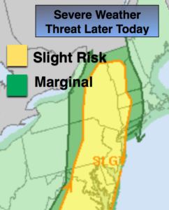
Today will be the most humid day of the week with a deep Southerly flow in place. Scattered morning showers and a few storms will move off the coast. Hazy sun and uncomfortable conditions will be with us into the afternoon. A energetic upper level trough will swing though this afternoon. The ingredients are there for scattered strong to severe storms this afternoon and evening. Severe storms contain at least one of the following criteria: winds in excess of 58mph and or 1″ hail. Keep an eye to the sky for threatening weather after 1PM.
The fireworks will taper off this evening and skies will be partly cloudy.
A cool front will sweep through later Thursday. This front looks to come through dry as moisture is limited although an isolated storm can’t be ruled out. The humidity will still be noticeable.
Friday will be sunny and comfortable as humidity levels will be low.
At this time, the weekend looks fantastic with plenty of sun and low humidity!
Keep it here for a no nonsense, no hype forecast.
Today:
Hazy, warm and humid. Scattered afternoon showers and storms. Highs in the mid to upper 80s. South winds at 8-15mph.
Tonight:
Spotty evening storms, otherwise partly cloudy and muggy. Lows in the lower to mid 70s in urban areas, the 60s inland. Southwest to West winds 5-10mph.
Thursday:
Partly sunny. An isolated afternoon storm is possible. Highs in the mid to upper 80s.
Friday:
Sunny. Much lower humidity. Highs in the mid 80s.
Saturday:
Sunny and comfortable. A top ten day. Highs in the mid 80s.
Sunday:
Sunny and comfortable. Another top ten day. Highs in the mid 80s.