Synopsis:
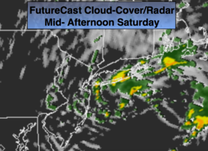
Fall conditions will be with us this weekend as high pressure works toward the Northeast. September’s finale will feature sunshine giving way to a mix of clouds and sun. A disturbance in the upper atmosphere will spark spotty showers later this morning and afternoon. It won’t be a washout FutureCast Cloud Cover/Radar above.
It’ll be very cool tonight as a cold pool of air works over the region.
Sunday, October’s debut, will be spectacular with wall to wall sunshine and seasonal readings.
High pressure will be expansive and cover the entire Eastern one half of the country for the beginning of the workweek. We can expect a string of gorgeous fall days.
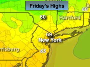
Today:
Sun will give way to a mix of clouds and sun. Spotty showers are possible. Very cool. Highs in the mid 60s in urban areas, the upper 50s North and West. North wind increasing to 15-25mph.
Tonight:
Clearing skies. Lows near 50º in the City, near 40º well inland. North wind decreasing to 5-10mph.
Sunday:
Sunny. Highs in the upper 60s.
Monday:
Sunny. Highs in the lower to mid 70s.
Tuesday:
Sunny. Highs in the lower to mid 70s.
Wednesday:
Sunny and mild. Highs in the upper 70s.
Keep it here for a no nonsense, no hype forecast.