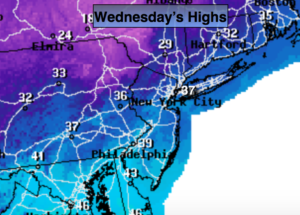
Synopsis:
Winter-like temperatures will be with us today into tonight as cold high pressure moves in from Canada. Highs will only be in the 30s but the wind will add a bite. Wind chills will be in the 20s for much of the day-hardly feeling like Spring. Winds will gust up to 45mph. It’ll be frigid tonight with lows in the teens to lower 20s.
A slow moderation in temperature will occur by the end of the week.
The weekend will feature a 50/50 split with Saturday being the better of the two days. Under partly sunny skies highs will warm to around 60º on Saturday. On Sunday a warm front will approach with periods of rain. The wind will be off the cold Atlantic. Highs will only be in the lower 40s. It will be raw to say the least.
Stay Tuned.
Today:
Mostly sunny, cold and windy. Highs in the mid to upper 30s. Wind chills will be in the 20s. Northwest winds at 15-30mph with gusts to 45mph.
Tonight:
Clear and frigid. Lows in the lower 20s in the City, the teens inland. Northwest winds 15-30mph and diminishing late.
Thursday:
Sunny and chilly. Highs in the lower 40s.
Friday:
More clouds than sun. Scattered showers are possible, especially inland. Highs in the mid to upper 40s.
Saturday:
Partly sunny and warm. Highs around 60º.
Sunday:
Cloudy with on and off rain. Much colder. Highs in the lower 40s.
Stay Tuned.
Keep it here for a no nonsense, no hype forecast.