Synopsis:
A mild day is expected today ahead of a cold front. Spotty Showers are possible South of the City early this morning otherwise, a mix of clouds and sun is expected.
A cold blast arrives midweek with highs only in the upper 30s Wednesday.
Tranquil conditions are expected for the remainder of the week. No major storms are looming. The next chance of rain is Sunday.
Stay Tuned.
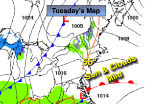
Today:
Clouds will give way to more sunshine during the afternoon. Spotty showers are possible South of the City this morning. Highs in the mid 50s. West wind at 5-10mph.
Tonight:
Clear and much colder. Becoming Windy late. Lows around freezing in the City, the upper 20s inland. Northwest winds increasing to 15-30mph late.
Wednesday:
Mostly sunny, much colder Highs in the mid to upper 30s.
Thursday:
Sunny and chilly. Highs in the lower 40s.
Friday:
Partly sunny and pleasant. Highs around 50º.
Saturday:
Partly sunny and warm. Highs around 60º.
Stay Tuned.
Keep it here for a no nonsense, no hype forecast.