Synopsis:
Energy pivoting around the a storm will caused scattered snow showers this evening. Some areas may pick up a quick coating. An unusually cold airmass will be over the Northeast through tomorrow with a persistent Northwesterly flow from Canada. Winds will continue to be brisk though tomorrow making for very low wind chills.
Temperatures will finally reach 40º by weeks end as the storm over Eastern Canada loses its influence on our area.
A disorganized area of low pressure will work in from the Ohio Valley Friday night and Saturday. At this time, light rain, or a mix of wet snow and rain is possible.
Stay Tuned.
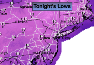
Tonight:
Leftover snow showers, otherwise mostly cloudy. Lows around 20º in the City, the teens inland. West to Northwest winds at 15-25mph with higher gusts. Wind Chills will be in the single digits and teens, almost unheard of for mid March.
Thursday:
Partly sunny, breezy and cold. Highs in the mid 30s. West Northwest wind at 15-25mph.
Friday:
Mostly sunny. Not as harsh. Highs around 40º.
Saturday:
Rain and or wet snow showers, otherwise mostly cloudy. Highs in the lower 40s.
Sunday:
Partly sunny. Highs in the lower 40s.
Monday:
Mostly cloudy. Highs in the mid 40s. Spring arrives at 6:28am.
Stay Tuned.
Keep it here for a no nonsense, no hype forecast.