Synopsis:
The storm that plagued our region with heavy snow, sleet, rain and wind will continue to move into Northern New England today. An unusually cold airmass will be over the Northeast in its wake. Temperatures will be hard pressed to get to freezing and the winds will gust to over 40mph. Making for wind chills in the teens. Energy pivoting around the storm will spark a round of snow showers this afternoon. Some areas may pick up a quick coating.
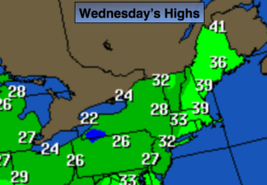
The next couple of days will be influenced by the strong storm in Eastern Canada. Winds will be busy through tomorrow with below average temperatures.
Temperatures will finally reach 40º by weeks end.
A disorganized area of low pressure will work in from the Ohio Valley Friday night and Saturday morning. At this time, light rain, or a mix of wet snow and rain is possible.
Stay Tuned.
Today:
Mostly cloudy. Snow showers, most likely in the afternoon. Windy and cold. Highs around freezing. West to Northwest winds at 15-30mph with gusts to 40mph.
Tonight:
Leftover snow showers, otherwise mostly cloudy. Lows around 20º in the City, the teens inland. West to Northwest winds at 15-25mph with higher gusts.
Thursday:
Partly sunny, breezy and cold. Highs in the mid 30s.
Friday:
Mostly sunny. Not as harsh. Highs around 40º.
Saturday:
Morning rain and or wet snow, otherwise becoming partly sunny. Highs in the lower 40s.
Sunday:
Partly sunny. Highs in the lower 40s.
Stay Tuned.
Keep it here for a no nonsense, no hype forecast.