Synopsis:
The storm that plagued our region with heavy snow, sleet, rain and wind will continue to move off the New England tonight.
Yes, I busted over a large part of the tri-state area with snow amounts. I’ll always admit a bust. It happens. Meteorology is a fluid science with the atmosphere constantly in motion and some parameters go by undetected. The NAM outperformed all the other models with this storm . I truly believe that many of us in this field, including myself, did not put enough wait on this model. With that being said I have milk and eggs for sale at the Marshall residence for half price!
Scattered snow showers are expected overnight with an additional dusting in spots, otherwise mostly cloudy and cold. Gusty winds will continue. An standing water or slush will freeze solid.
The next couple of days will be influenced by the strong storm in Eastern Canada. Winds will be busy the next two days. Another round of snow showers are possible Wednesday afternoon.
Temperatures will finally reach 40º by weeks end.
Tonight:
Leftover snow showers at times otherwise mostly cloudy. Lows around 20º in the City, the teens inland. West to Northwest winds at 15-30mph with higher gusts.
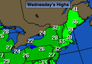
Wednesday:
Mostly cloudy. Snow showers, most likely in the afternoon. Windy and cold. Highs around freezing. West to Northwest winds at 15-30mph with gusts to 35mph.
Thursday:
Partly sunny, breezy and cold. Highs in the mid 30s.
Friday:
Mostly sunny. Not as harsh. Highs around 40º.
Saturday:
Morning rain and or snow showers, otherwise becoming partly sunny. Highs in the lower 40s.
Sunday:
Partly sunny. Highs in the lower 40s.
Stay Tuned.
Keep it here for a no nonsense, no hype forecast.