Synopsis:
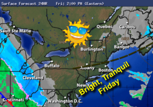
High pressure over the Southeast will result in plenty of sunshine and milder readings for today.
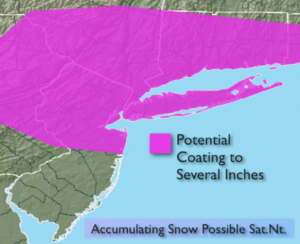
A disorganized area of low pressure will work in from the Ohio Valley Friday night. The system has good upper level support so as it approaches and moves off the NJ coast it should strengthen. Rain and snow showers are likely on Saturday. By Saturday night the strengthening storm South of Long Island should throw back an arc of snow toward the coast. How far West this snow gets is still in question. At this time, please be aware that an accumulation is possible. The second map above is where the stripe of accumulating snow is possible. We’ll fine tune possible amounts later this afternoon. Most of what falls will be at night so the strong March sun will not be a factor in limiting accumulation. The system will move farther offshore Sunday. The sun will return later in the day.
Spring arrives on Monday at 6:28AM and not soon enough.
Stay Tuned.
Today:
Mostly sunny. Pleasant. Highs in the lower 40s. West to Northwest winds at 8-12mph.
Tonight:
Mostly clear then becoming cloudy late. Rain and snow showers possible toward dawn. Lows around freezing in the City, the 20s inland. West to Northeast winds at 5mph.
Saturday:
Periods of rain and or wet snow. Highs in the upper 30s to lower 40s.
Sunday:
Early morning snow is possible, especially by the coast otherwise becoming partly sunny. Highs in the lower 40s.
Monday:
Partly sunny. Highs in the mid 40s. Spring arrives at 6:28am.
Tuesday:
Partly sunny, more seasonal. Highs in the upper 40s. The average high is 50º.
Stay Tuned.
Keep it here for a no nonsense, no hype forecast.