Synopsis:
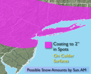
A clipper (rapidly moving storm) will move from the Great Lakes and through the area this weekend. On and off rain and wet snow showers are likely today. The latest computer guidance shows the storm now developing farther off the coast. This will result in some light wet snow at times tonight into Sunday morning. Any wet snow will taper off at the coast Sunday morning as the system moves farther offshore. The sun will return later in the day. A coating is likely in spots, especially on colder surfaces. This will not be a big deal.
Spring arrives on Monday at 6:28AM and not soon enough.
Stay Tuned.
Today:
On an off rain and snow showers. Highs in the upper 30s to lower 40s. East winds at 10-20mph.
Tonight:
Scattered areas of light wet snow. Lows around freezing in the City, the upper 20s inland. West to East winds at 5mph.
Sunday:
Early morning snow is possible, especially by the coast otherwise becoming partly sunny. Highs in the lower 40s.
Monday:
Partly sunny. Highs in the mid 40s. Spring arrives at 6:28am.
Tuesday:
Partly sunny, more seasonal. Highs in the upper 40s. The average high is 50º.
Wednesday:
Partly sunny, much colder Highs in the upper 30s.
Stay Tuned.
Keep it here for a no nonsense, no hype forecast.