Synopsis:
A storm will move well off the East coast today. Any clouds will give way to mostly sunny skies. Temperatures will be a few degrees below average.
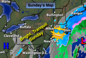
Spring arrives tomorrow at 6:28AM. It will feel like a typical first day of Spring with highs around 50º under mostly sunny conditions.
A mild day is expected Tuesday ahead of a cold front.
A cold blast arrives midweek with highs only in the upper 30s Wednesday.
Stay Tuned.
Today:
Becoming mostly sunny and breezy. Highs in the mid 40s. North wind at 15-25mph.
Tonight:
Mostly clear. Lows in the lower to mid 30s in the City, the 20s inland. Northwest winds diminishing to 8-12mph after midnight.
Monday:
Mostly sunny, more seasonal. Highs around 50º. The average high is 50º. Spring arrives at 6:28am.
Tuesday:
Partly sunny. Highs in the lower 50s.
Wednesday:
Mostly sunny, much colder Highs in the mid to upper 30s.
Thursday:
Sunny and chilly. Highs in the lower 40s.
Stay Tuned.
Keep it here for a no nonsense, no hype forecast.