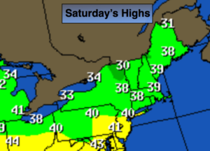
Mostly Cloudy. Very Cold & Windy. PM Snow Showers


Synopsis:

The storm that plagued our region with heavy snow, sleet, rain and wind will continue to move into Northern New England today. An unusually cold airmass will be over the Northeast in its wake. Temperatures will be hard pressed to get to freezing and the winds will gust to over 40mph. Making for wind chills in the teens.  Energy pivoting around the storm will spark a round of snow showers this afternoon. Some areas may pick up a quick coating.

The next couple of days will be influenced by the strong storm in Eastern Canada. Winds will be busy through tomorrow with below average temperatures.

Temperatures will finally reach 40º by weeks end.

A disorganized area of low pressure will work in from the Ohio Valley Friday night and Saturday morning. At this time, light rain, or a mix of wet snow and rain is possible.

Stay Tuned.

Today:

Mostly cloudy. Snow showers, most likely in the afternoon. Windy and cold. Highs around freezing. West to Northwest winds at 15-30mph with gusts to 40mph.

Tonight:

Leftover snow showers, otherwise mostly cloudy. Lows around 20º in the City, the teens inland. West to Northwest winds at 15-25mph with higher gusts.

Thursday:

Partly sunny, breezy and cold. Highs in the mid 30s.

Friday:

Mostly sunny. Not as harsh. Highs around 40º.

Saturday:

Morning rain and or wet snow, otherwise becoming partly sunny. Highs in the lower 40s.

Sunday:

Partly sunny. Highs in the lower 40s.

Stay Tuned.

Keep it here for a no nonsense, no hype forecast.


Scattered Snow Showers Overnight. Refreeze. Gusty Winds…


Synopsis:

The storm that plagued our region with heavy snow, sleet, rain and wind will continue to move off the New England tonight.

Yes, I busted over a large part of the tri-state area with snow amounts. I’ll always admit a bust. It happens. Meteorology is a fluid science with the atmosphere constantly in motion and some parameters go by undetected. The NAM outperformed all the other models with this storm . I truly believe that many of us in this field, including myself, did not put enough wait on this model. With that being said I have milk and eggs for sale at the Marshall residence for half price!

Scattered snow showers are expected overnight with an additional dusting in spots, otherwise mostly cloudy and cold. Gusty winds will continue. An standing water or slush will freeze solid.

The next couple of days will be influenced by the strong storm in Eastern Canada. Winds will be busy the next two days.  Another round of snow showers are possible Wednesday afternoon.

Temperatures will finally reach 40º by weeks end.

Tonight:

Leftover snow showers at times otherwise mostly cloudy. Lows around 20º in the City, the teens inland. West to Northwest winds at 15-30mph with higher gusts.

Wednesday:

Mostly cloudy. Snow showers, most likely in the afternoon. Windy and cold. Highs around freezing. West to Northwest winds at 15-30mph with gusts to 35mph.

Thursday:

Partly sunny, breezy and cold. Highs in the mid 30s.

Friday:

Mostly sunny. Not as harsh. Highs around 40º.

Saturday:

Morning rain and or snow showers, otherwise becoming partly sunny. Highs in the lower 40s.

Sunday:

Partly sunny. Highs in the lower 40s.

Stay Tuned.

Keep it here for a no nonsense, no hype forecast.


Storm Slowly Winds Down. High Winds Continue…


Synopsis:

The storm that plagued our region with heavy snow, sleet, rain and wind will continue to move toward Eastern Long Island and off the New England coast this afternoon and into tonight.

Yes, I busted over a large part of the tri-state area with snow amounts. I’ll always admit a bust. It happens. Meteorology is a fluid science with the atmosphere constantly in motion and some parameters go by undetected. The NAM outperformed all the other models with this storm . I truly believe that many of us in this field, including myself, did not put enough wait on this model. With that being said I have milk and eggs for sale at the Marshall residence for half price!

The heaviest precipitation will move North and East of the City this afternoon.  Scattered areas of light snow will be left behind the departing system (the what to expect map is above).

Stay safe and please clear the walkways before it all refreezes.

Tonight:

Leftover snow showers at times otherwise mostly cloudy. Lows around 20º in the City, the teens inland. West to Northwest winds at 15-30mph with higher gusts.

Wednesday:

Mostly cloudy. Snow showers. Windy and cold. Highs around freezing. West to Northwest winds at 15-30mph with gusts to 35mph.

Thursday:

Partly sunny, breezy and cold. Highs in the mid 30s.

Friday:

Mostly sunny. Not as harsh. Highs around 40º.

Saturday:

Morning rain and or snow showers, otherwise becoming partly sunny. Highs in the lower 40s.

Sunday:

Partly sunny. Highs in the lower 40s.

Stay Tuned.

Keep it here for a no nonsense, no hype forecast.


Historic Storm N/W. Blizzard Warnings/Winter Storm Warnings…


Synopsis:

***Blizzard & Winter Storm Warnings are in effect for inland areas Today***

Blizzard is defined as:

1)Heavy falling Snow or blowing snow

2)Visibility below 1/4mile

3)Winds in excess of 35mph

These conditions need to persist for 3 or more consecutive hours.

The latest computer guidance continues to suggest that epic amounts of snow are likely for areas North & West of New York City (potential snow amounts, warnings and What to Expect graphics are above). The storm will be going through bombogenesis (a rapidly intensifying storm where the pressure falls are very dramatic) just off the coast of NJ. This will bring Snowfall rates of 2″-4″ and hour over inland areas this morning. The brunt of the storm will be from now into mid-day. Thunder snow is possible with whiteout conditions. The latest models show the intense storm now hugging the coast of NJ and Long Island. Because of this development with the track of the storm coastal NJ many areas have gone over to rain or sleet. This will cut back on snow amounts greatly. Areas from the City and Eastward into Long Island will experience this warming as well, resulting in a cutback in snow totals.

Coastal flooding is possible at times of high tides. Winds will gust between 40-60mph on the coast and to 35-40 mph inland. Scattered power outages are a concern do to the highs winds and heavy wet snow that may bring down tree limbs.

Please be safe.

Stay tuned.

Today:

Snow. Heavy at times inland. Heavy sleet back to snow later this morning along the I-95 corridor. Windswept rain along the coast. Very windy, especially at the coast. Highs around freezing. Northeast to Northwest wind at 15-35mph gusts to 60mph at the coast.

Tonight:

Leftover snow showers are times otherwise mostly cloudy. Lows around 20º in the City, the teens inland. Northwest winds at 15-30mph with higher gusts.

Wednesday:

Mostly cloudy. Snow showers. Windy and cold. Highs around freezing.

Thursday:

Partly sunny, breezy and cold. Highs in the mid 30s.

Friday:

Mostly sunny and chilly. Highs in the upper 30s.

Saturday:

Mostly cloudy. Scattered snow showers. Highs around 40.

Stay Tuned.

Keep it here for a no nonsense, no hype forecast.


Blizzard Warning & Winter Storm Warnings: Tonight & Tuesday…

Synopsis:

***Blizzard Warning is in effect for all of New York City, much of Long Island, coastal Connecticut & Eastern NJ. Winter Storm Warnings are in effect for the remainder of the tri-state area for late tonight and Tuesday***

Today will be the calm before the storm. High pressure will remain over the Northeast and continue to maintain the cold air that has been in place.

The latest computer guidance suggests that the storm potential will become a reality as all of the models have epic amounts of snow on the way. The models show the storm is stronger and has higher precipitation amounts. The snow will get going around midnight and come down heavy at times later tonight and Tuesday morning. Snowfall rates of 1″-3″ and hour are likely. The brunt of the storm will be from 4AM-Mid-day Tuesday. Thunder snow is possible with whiteout conditions. Coastal flooding is possible at times of high tides on Tuesday. Winds will gust between 40-60mph on the coast. Scattered power outages are a concern do to the highs winds and heavy wet snow that may bring down tree limbs.

A few questions that still need to be answered and probably won’t get answer until just before the storm gets going is: How much mixing occurs along the coast? Where does the heaviest precipitation banding set up?

Stay tuned.

Today:

Mostly sunny and chilly. Highs in the mid 30s. Northwest to Southeast wind at 5mph.

Tonight:

Snow developing around midnight. The snow will become heavy at times. Lows in the mid 20s in the City, around 20º inland. Winds becoming Northeast and increasing to 15-30mph.

Tuesday:

Snow. Heavy at times. A mix at times at the coast. Very windy, especially at the coast. Highs around freezing.

Wednesday:

Mostly cloudy. Snow showers. Windy and cold. Highs around freezing.

Thursday:

Partly sunny, breezy and cold. Highs in the mid 30s.

Friday:

Partly sunny, breezy and chilly. Highs in the upper 30s.

Stay Tuned.

Keep it here for a no nonsense, no hype forecast.


5PM Sun: Blizzard Watch & Winter Storm Warnings for Tuesday…

Synopsis:

***Blizzard Watch is in effect for all of New York City, Long Island, coastal Connecticut & Northeastern NJ. Winter Storm Warnings & Watches are in effect for the remainder of the tri-state area for late Monday Night and Tuesday***

Tonight and Monday will be the calm before the storm. High pressure will remain over the Northeast and continue to maintain the cold air that has been in place.

The latest computer guidance suggests that the storm potential will become a reality as all of the models have a good hit of snow. Some models have monster amounts while a few have lesser amounts, but still significant. A few questions that still need to be answered and probably won’t get answer until just before the storm gets going is: How much mixing occurs along the coast? Where does the heaviest precipitation banding set up?

A Blizzard Watch has been posted for the possibility of blizzard conditions (heavy snow and high winds) from NYC vicinity and to the East. Winter storm warnings are up most of the remainder of the region for the likelihood of  significant snowfall. A Winter storm watch is in effect for coastal NJ for the possibility of significant snow.

Confidence continues to increase that much of the region will experience a major snowstorm. Possible snow amounts are above. These amounts are a generalization and will most likely change as we get closer to the onset of the storm. The snow will begin Monday Night and wind down Tuesday Night.

Stay tuned.

Tonight:

Mostly clear and cold. Lows around 20º in the City, the teens and single digits inland. Northwest winds diminishing to 5mph or less.

Monday:

Mostly sunny and chilly. Highs in the mid 30s. Northwest to Southeast wind at 5mph.

Tuesday:

Snow or a mix, heavy at times. Very windy, especially at the coast. Highs around freezing.

Wednesday:

Mostly cloudy. Snow showers. Windy and cold. Highs around freezing.

Thursday:

Partly sunny, breezy and cold. Highs in the mid 30s.

Friday:

Partly sunny, breezy and chilly. Highs in the upper 30s.

Stay Tuned.

Keep it here for a no nonsense, no hype forecast.


Blizzard Watch & Winter Storm Watch for Tuesday…

Synopsis:

***Blizzard Watch is in effect for all of New York City, Long Island, coastal Connecticut & Northeastern NJ. A Winter Storm Watch is in effect for the remainder of the tri-state area for late Monday Night and Tuesday***

An Arctic airmass will be over the region this weekend. Temperatures will be well below average with highs most likely remaining below freezing Saturday and getting to around freezing on Sunday. Both days will feature a mix of sun and clouds.

The potential storm is on the map for Tuesday. The ingredients are there for a significant snowfall for many areas (or a mix at times at coast). Will it all come together?  The signals are there for a large, intense storm. It’s the details that need to be ironed out. How much mixing occurs along the coast? Where does the heaviest precipitation banding set up?

A Blizzard Watch has been posted for the possibility of blizzard conditions (heavy snow and high winds) from NYC vicinity and to the East. Winter storm watches are up elsewhere for the possibility of  significant snowfall. A watch means just that we watch the situation. It is not a warning.

Confidence continues to increase that much of the region will experience a major snowstorm. Possible snow amounts are above. These amounts are a generalization and will most likely change as we get closer to the onset of the storm. The snow will begin Monday Night and wind down Tuesday Night.

Stay tuned.

Today:

Partly sunny and cold. Highs around freezing. Northwest winds at 10-20mph.

Tonight:

Mostly clear and cold. Lows in the lower 20s in the City, the teens inland. Northwest winds at5-10mph.

Monday:

Mostly sunny and chilly. Highs in the mid 30s.

Tuesday:

Storm Potential. Snow or a mix, heavy at times. Highs around freezing.

Wednesday:

Mostly cloudy. Snow showers. Windy and cold. Highs around freezing.

Thursday:

Partly sunny, breezy and cold. Highs in the mid 30s.

Stay Tuned.

Keep it here for a no nonsense, no hype forecast.


Bitterly Blast This Weekend. Storm Potential Tuesday…


Synopsis:

An Arctic airmass will be over the region this weekend. Temperatures will be well below average with highs most likely remaining below freezing Saturday and getting to around freezing on Sunday. Both days will feature a mix of sun and clouds.

There is a potential storm on the horizon for Tuesday. The ingredients are there for a significant snowfall for many areas (or a mix at times at coast). Will it all come together?  The signals are there for a large, intense storm. It’s the details that need to be ironed out. Those details will make all the difference in the world between a snow/rain mix or a raging snowstorm. The latest computer guidance of our two main models are more similar now, so confidence has increased on the storm threat. Both the GFS and European models above show an intensifying storm off the NJ coast Tuesday with heavy snow and a heavy mix at the coast. This is taking both of these models verbatim. Yes, the confidence is increasing that many areas will see significant snow with a mix at the coast. Snow amounts will not be given out yet as the system is still 3 days away. Those that are giving out numbers are not reliable.

Stay tuned.

Today:

Partly sunny, windy and cold. Highs around 30º. Wind chills in the teens and 20s. Northwest wind at 15-30mph with higher gusts.

Tonight:

Mostly clear and bitterly cold. Lows in the upper teens in the City, the lower teens inland. Northwest wind at 15-25mph and diminishing. Wind chill factors will be near zero.

Sunday:

Partly sunny and cold. Highs in the lower to mid 30s.

Monday:

Mostly sunny and chilly. Highs in the mid 30s.

Tuesday:

Storm Potential. Snow or a mix, heavy at times. Highs around freezing.

Wednesday:

Becoming partly sunny, windy and cold. Highs around freezing.

Stay Tuned.

Keep it here for a no nonsense, no hype forecast.


Quick Hitting Accumulating Snow Today…


Synopsis:

A cold front with a wave of low pressure will move through the region today with a period of snow. The snow may begin as rain over the City and to the South early this morning but will quickly go over to snow. It will be a quick hitter with the snow ending by mid-day or early afternoon. 2″-5″ is expected on colder surfaces with lighter amounts to the North and South of this band (map above). Eastern Long Island may approach 6″. For this reason a Winter Storm Warning has been issued. The morning commute will become treacherous where the heaviest snow falls. The sun may make an appearance later in the day inland.

The flood gates will open up from Canada and cold air will funnel into the area this weekend. Temperatures will be well below average with highs most likely remaining below freezing Saturday and getting just above freezing on Sunday.

There is another potential storm on the horizon for Tuesday. The ingredients are there for a decent snowfall, will they all come together?  Plenty of time to watch this one. Yep, key word- POTENTIAL. Stay tuned.

Today:

Snow likely. The snow will taper off during mid-day to early afternoon from West to East. Late day sun is possible. Highs in the upper 30s. North to Northeast winds becoming Northwest at 10-20mph with gusts to 30mph later today.

Tonight:

Mostly clear and bitterly cold. Lows in the upper teens in the City, the lower teens inland. Northwest wind at 15-30mph with gusts to 35mph. Wind chill factors will be near zero.

Saturday:

Partly sunny, windy and cold. Highs around 30º. Wind chills in the teens and 20s.

Sunday:

Partly sunny and cold. Highs in the lower to mid 30s.

Monday:

Mostly sunny and chilly. Highs in the mid 30s.

Tuesday:

Snow Possible. Highs around freezing.

Stay Tuned.

Keep it here for a no nonsense, no hype forecast.


One More Mild Day. Some Snow Friday…


Synopsis:

High pressure to our South and low pressure over Eastern Canada will result in a breezy, mild day.

On Friday a cold front with a weak wave of low pressure will move through the region. A period of snow is likely. Where the stripe of snow develops and moves in will determine how much will accumulate. At this time a coating to possibly three inches (in colder areas) is in the forecast, map above. The sun may make an appearance later in the day.

The flood gates will open up from Canada and cold air will funnel into the area this weekend. Temperatures will be well below average with highs most likely remaining below freezing Saturday and getting just above freezing on Sunday.

There is another potential storm on the horizon for Tuesday. Yep, again key word POTENTIAL. Stay tuned.

Today:

Mostly sunny, mild. Highs in the mid 50s. West 10-20mph.

Tonight:

Thickening clouds with rain and snow developing toward midnight. The mix to will turn to all snow overnight. Lows in the mid 30s in the City, near 30º inland. West wind will become North Northeast at 10-15mph.

Friday:

A period of snow mainly in the morning through mid-day. Late day sun is possible. Highs around 40º.

Saturday:

Partly sunny and cold. Highs around 30º.

Sunday:

Partly sunny and cold. Highs in the lower to mid 30s.

Monday:

Mostly sunny and chilly. Highs in the mid 30s.

Stay Tuned.

Keep it here for a no nonsense, no hype forecast.