Synopsis:
High pressure overhead will result in a frigid night inland. Readings will bottom out near 10º in the sheltered valleys to the teens and 20s just outside the City. In the urban corridor temperatures will be around freezing under partly cloudy skies.
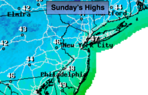
It won’t be as harsh on Sunday with a mix of sun and clouds the mercury will recover to the upper 40s.
Tranquil conditions are expected heading into the workweek as high pressure systems dominate. Readings will be near average. The average high is in the mid 50s. A weak area of low pressure will ride up and off the coast Monday mostly likely sparing the region of any precipitation.
Stay tuned:
Tonight:
Partly cloudy and cold. Readings will not be as low as last night in urban areas. Lows in the lower to mid 30s in the City, the 20’s and teens to near 10º inland. Northeast winds will be nearly calm.
Sunday:
Partly sunny and cool. Highs in the mid to upper 40s. Northeast to Southeast wind at 5mph.
Monday:
Sun and clouds. A stray shower is possible. Highs around 50º.
Tuesday:
Mostly sunny. Highs around 50º.
Wednesday:
Mostly sunny. Highs in the lower 50s.
Thursday:
Partly sunny. Highs in the mid 50s.
Keep it here for a no nonsense, no hype forecast.