Synopsis:
Record lows have been tied or broken in most locations this morning. Readings got down to the teens and lower to mid 20s-the first widespread hard freeze of the season.
Cold sunshine will be with us today as readings will remain well below average. Thankfully, the wind will be light with high pressure overhead. It won’t be as harsh on Sunday with the mercury recovering to near 50º.
Tranquil conditions are expected heading into the workweek as high pressure systems dominate. Readings will be near average. The average high is in the mid 50s. A weak area of low pressure will ride up and off the coast Monday mostly likely sparing the region of any precipitation.
Stay tuned:
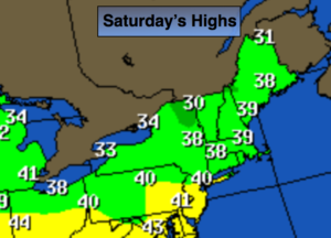
Today:
Sunny and cold. Highs will only reach the 30s to around 40º. North wind at 5-10mph.
Tonight:
Partly cloudy and cold. Readings will not be as low as last night in urban areas. Lows in the lower to mid 30s in the City, the teens to near 10º inland. Northeast winds will be nearly calm.
Sunday:
Partly sunny and cool. Highs around 50.
Monday:
Sun and clouds. A stray shower is possible. Highs in the lower 50s.
Tuesday:
Sunny. Highs in the lower 50s.
Wednesday:
Party sunny. Highs in the lower 50s.
Keep it here for a no nonsense, no hype forecast.