Synopsis:
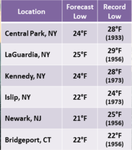
Record cold temperatures are expected overnight into early Saturday morning. The record lows graphic is above. This is the first widespread hard freeze and a Freeze Warning has been posted for the New York City Vicinity for through Saturday morning. Winds will thankfully diminish.
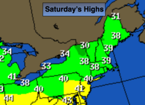
The weekend will feature plenty of sunshine with high pressure overhead. readings will be well below average on Saturday (2nd map above) recovering to near 50º by Sunday.
Tranquil conditions are expected heading into the workweek as high pressure systems dominate. Readings will be near average. The average high is in the mid 50s.
Stay tuned.
Tonight:
Clear and Frigid with record low temperatures. Lows in the lower to mid 20s in the City, the teens inland. Northwest winds diminishing to 8-12mph.
Saturday:
Sunny and cold. Highs will only reach the 30s to around 40º. North wind at 5-10mph.
Sunday:
Mostly sunny and cool. Highs around 50.
Monday:
Sun and clouds. A stray shower is possible. Highs in the lower 50s.
Tuesday:
Sunny. Highs in the lower 50s.
Wednesday:
Party sunny. Highs in the lower 50s.
Keep it here for a no nonsense, no hype forecast.