Synopsis:
High pressure will continue to dominate our region through today with fair conditions and below average temperatures. The average high is 57º.
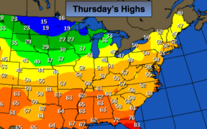
It’ll turn much colder Friday into Saturday as a significant cold front moves by. The map above depicts only teens for highs in the Northern Plains on Thursday behind the cold front. This cold blast will bring a chilling reminder that Winter is not far off. A hard freeze is expected throughout the tri-state area Friday night-readings will be in the 20s along the coast, the teens well inland. A Freeze Watch has been posted for the New York City Vicinity for Friday Evening through Saturday morning.
The weekend will feature plenty of sunshine with readings well below average on Saturday recovering to near 50º by Sunday.
Stay tuned.
Today:
Partly sunny, cool. Highs in the lower 50s. Northeast to Southeast winds at 5mph.
Tonight:
Partly cloudy. Cold. Lows in the 30s throughout. Southwest to West wind at 5-10mph. Increasing to 15-25mph with gusts to 35mph after midnight.
Friday:
Partly sunny, windy and much colder. Highs remaining in the 30s. Temperatures falling to below freezing North and west by late-afternoon.
Saturday:
Sunny and cold. Morning lows will be in the teens North and West, the mid 20s in the City. Highs will only reach the lower 40s.
Sunday:
Partly sunny and cool. Highs around 50.
Monday:
Mostly cloudy with a chance of rain. Highs around 50.
Keep it here for a no nonsense, no hype forecast.