Synopsis:
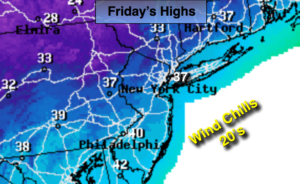
A significant cold front will move through in the wee hours of the morning Friday. Before it’s arrival; it’ll be relatively mild overnight with spotty showers possible. It’ll turn much colder by sunrise with readings dropping from near 50º to the 30s within a couple of hours. Highs on Friday will struggle to remain in the mid 30s and then drop to near freezing toward sunset. Winds will be strong gusting up to 45mph after the passage of the front through early afternoon Friday. This cold blast will bring a chilling reminder that Winter is not far off.
A hard freeze is expected throughout the tri-state area Friday night-readings will be in the 20s along the coast, the teens well inland. A Freeze Warning has been posted for the New York City Vicinity for Friday Evening through Saturday morning.
The weekend will feature plenty of sunshine with readings well below average on Saturday recovering to near 50º by Sunday.
Tranquil conditions are expected heading into the workweek with readings near average. The average high is in the mid 50s.
Stay tuned.
Tonight:
Mostly cloudy with spotty showers. Mild for a good portion of the night with readings in the 40s to near 50º at the coast. Southwest to West wind at 5-10mph. Temperatures will plummet into the 30s once the front moves through after 3am. The winds will shift to the West and increase to 15-30mph with gusts up to 45mph.
Friday:
Partly sunny, windy and much colder. Highs remaining in the 30s. Temperatures falling to below freezing North and west by late-afternoon. Northwest winds at 15-30mph with gusts to 45mph. Winds will slowly diminish by late afternoon.
Saturday:
Sunny and cold. Morning lows will be in the teens North and West, the mid 20s in the City. Highs will only reach the lower 40s.
Sunday:
Mostly sunny and cool. Highs around 50.
Monday:
Mostly cloudy with spotty showers. Highs in the lower 50s.
Tuesday:
Sunny. Highs in the lower 50s.
Keep it here for a no nonsense, no hype forecast.