Synopsis:
It’ll finally feel like fall as temperatures have come down to more seasonal levels. High pressure over Eastern Canada is responsible for our cool down and the bright close to the workweek.
A wind off the ocean and moisture trapped at the lowest level of the atmosphere will cause clouds to roll in tonight and Saturday. Patchy drizzle is possible tonight and Saturday morning. Skies will be mostly cloudy and it’ll be cool.
The high pressure will move over the region and offshore Sunday. Temperatures will pop once again to well above the average highs as winds begin to turn to a Southerly direction. This high looks to park itself over the Eastern Seaboard into next week resulting in above average temperatures and dry conditions.
You know where to find a no hype, no nonsense forecast.
Stay tuned.
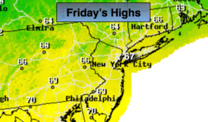
Today:
Mostly sunny, much cooler and less humid. Highs in the upper 60s (which is actually the average highs for this time of the year). Northeast winds at 8-12mph.
Tonight:
Mostly cloudy with areas of drizzle. Lows in the 50s throughout. East winds less than 5mph.
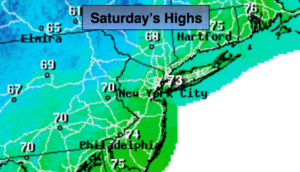
Saturday:
Mostly cloudy with patchy morning drizzle. Highs in the upper 60s.
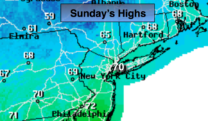
Sunday:
Mostly sunny, much warmer. Highs in the upper 70s.
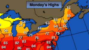
Monday:
Mostly sunny. Warm. Highs in the upper 70s.
Tuesday:
Mostly sunny. Warm. Highs in the upper 70s.
Keep it here for a no nonsense, no hype forecast.