Synopsis:
A weak cool front will approach the area today. On and off showers will be with us, meaning there will be dry times; it’ll be milder.
A ridge of high pressure will work in from the midwest Tuesday and Wednesday. Readings will be around five degrees below the average of the mid 60s.
Later Wednesday, a strong cold front will move through. Although it will pass the area rain-free it’ll supply the coldest air of the season so far Wednesday night and Thursday. It looks like Autumn wants to stick around.
You know where to find a no hype, no nonsense forecast.
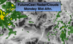
Monday:
Mostly cloudy with on and off showers. Milder. Highs in the mid to upper 60s. Southwest winds at 8-12mph.
Tonight:
Showers this evening, otherwise becoming partly cloudy late. Lows around 50º in the City, the 40s inland. Southwest to Northwest wind increasing to 10-20mph.
Tuesday:
Partly sunny, cooler. Highs in the upper 50s.
Wednesday:
Partly sunny, cool. Highs around 60º.
Thursday:
Partly sunny, breezy and much cooler. Highs around 50º.
Friday:
Mostly sunny. Highs in the upper 50s.
Keep it here for a no nonsense, no hype forecast.