Synopsis:
High pressure will move into the region today. A mix of clouds and sun is expected with cool readings. Temperatures will be about five degrees below the average high of 65º.
Moisture streaming in from the South and West will result in thickening clouds tonight with the chance of showers after midnight.
A weak front will move through the area on Monday with scattered showers; It’ll be milder.
Cool temperatures will stick around for the rest of the week as the flow is coming out of the Northwest. It will be dry. It looks like Autumn wants to stick around.
You know where to find a no hype, no nonsense forecast.
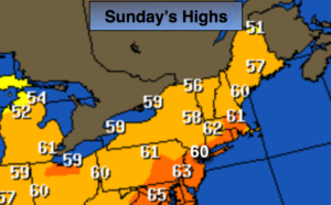
Sunday:
Clouds and sun. Cool. Highs around 60º. Northwest to Southwest winds at 5-10mph.
Tonight:
Mostly cloudy. Scattered showers possible late. Lows in the mid 50s in the City, the 40s inland. Southwest wind under 5mph.
Monday:
Mostly cloudy with scattered showers. Milder. Highs in the mid to upper 60s.
Tuesday:
Partly sunny, cooler. Highs around 60º.
Wednesday:
Partly sunny, cool. Highs around 60º.
Thursday:
Partly sunny, much cooler. Highs in the lower 50s.
Keep it here for a no nonsense, no hype forecast.