Synopsis:
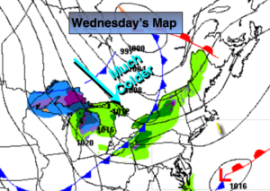
A ridge of high pressure will continue to influence our area resulting in fair, cool weather today. Later this afternoon, a strong cold front will move through with gusty winds. It should pass the area rain-free but a spot shower can’t be ruled out toward evening. The front will supply the coldest air of the season so far tonight and Thursday. Lows will be near freezing well inland tonight and readings on Thursday may not get out of the 40s for highs!
Friday will be bright and chilly.
Spotty showers are possible Saturday morning otherwise skies will be partly sunny. Another significant cold front will move our way Saturday night and Sunday.
It looks like Autumn wants to stick around.
You know where to find a no hype, no nonsense forecast.
Today:
Partly sunny, cool. Highs around 60º. Becoming windy later in the day. West wind increasing to 15-25mph by mid to late afternoon.
Tonight:
A spot evening shower is possible otherwise, mostly clear, windy and much colder. Lows in the upper 30s in the City, near freezing inland. Northwest winds at 15-25mph with gusts to 35mph.
Thursday:
Partly sunny, breezy and much colder. Highs in the upper 40s.
Friday:
Mostly sunny. Highs in the upper 50s.
Saturday:
Spotty morning showers otherwise partly sunny. Highs around 60º.
Sunday:
Partly sunny, windy and chilly. Highs around 50º.
Keep it here for a no nonsense, no hype forecast.