Synopsis:
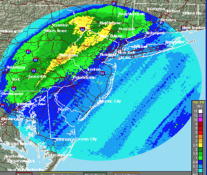
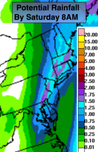
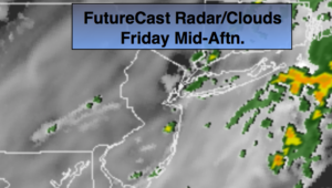
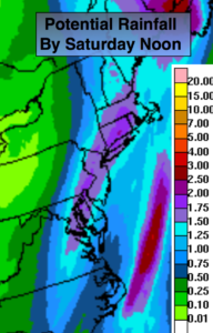
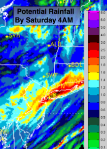
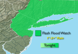
An area of low pressure will develop along a cold front near Washington, DC and move toward and through our area later today and tonight. Any morning sun will give way to thickening clouds. Rain will develop later in the day and continue into the night. The rain maybe heavy at times later this evening and tonight. A Flash Flood Watch has been posted for most of the tri-state area tonight. 1″-2″+ of rain is possible. The ground is still saturated form previous rains and many sewer drains are clogged with fallen leaves so it won’t take much to cause flooding of streets and highways. Also, streams, creeks and rivers remain at high levels. Flooding of these waterways are also possible. Never drive through a flooded roadway. TURN AROUND, DON’T DROWN.
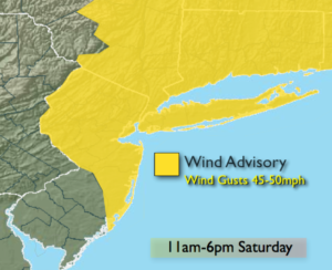
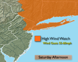
Once the low and front move off the coast late tonight; it’ll set the stage for a precipitation free weekend for a change! Low pressure in Canada and strong high pressure over the midwest will result in strong Northwest winds on Saturday, at least it’ll be partly sunny. Northwest wind gusts of 40mph are likely. Sunday-Veteran’s Day, will be chilly with abundant sunshine as high pressure moves in. Winds will relax.
Another low will move up the Eastern Seaboard Monday night into Tuesday. More rain is on the way. The coldest temperatures of the season so far will be with us by midweek next week.
You know where to find a no hype, no nonsense forecast.
Stay tuned.
Today:
Any early sun will give way to thickening clouds and rain by mid afternoon. Highs in the lower 50s. East winds increasing to 10-20mph this afternoon.
Tonight:
Rain. Heavy at times later this evening into early tonight. Lows around 40º. in the City, the 30s inland. East to West winds at 10-15mph.
Saturday:
Partly sunny, windy and chilly. Highs in the upper 40s.
Veterans’ Day:
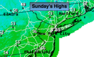
Sunny and unseasonably cool. Highs in the mid 40s.
Monday:
Morning sun, afternoon clouds. Highs in the upper 40s.
Tuesday:
Rain. Highs in the mid 50s.
Keep it here for a no nonsense, no hype forecast.