Synopsis:
Today will be the better half of the weekend with abundant sunshine, seasonal readings and light winds as high pressure dominates the Northeast. The sun will set an hour earlier then yesterday at 4:49PM, now that we are back to Eastern Standard Time.
The beginning of the workweek looks unsettled as the jet stream remains active and moisture moves up from the South. Another round of rain is expected Monday with an approaching warm front and then again Tuesday with an approaching cool front. The rain on Monday will develop during the mid to late morning. The steadiest rain on Tuesday will be in the afternoon and evening.
High pressure will be in control Wednesday and Thursday with abundant sunshine and comfortable readings.
You know where to find a no hype, no nonsense forecast.
Stay tuned.
Today:
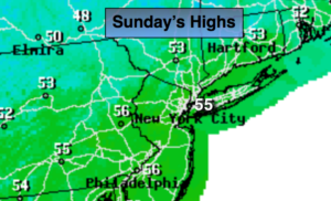
Sunny and seasonal. Highs in the mid 50s. Northwest to Northeast winds at 5mph.
Tonight:
Clear to partly cloudy. Lows in the mid 40s in the City, the 30s inland. East wind at 5-10mph.
Monday:
Cloudy with rain developing during the mid to late morning. Highs in the mid 50s.
Tuesday:
Mostly cloudy with spotty showers or areas of drizzle. Mild. Highs in the mid 60s. Rain will develop later in the day and continue into the night.
Wednesday:
Partly sunny, breezy and mild. Highs in the lower 60s.
Thursday:
Sunny & seasonal. Highs in the mid 50s.
Keep it here for a no nonsense, no hype forecast.