Synopsis:
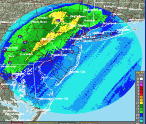
Low pressure over Southern NY State this morning will move into Northern New England this afternoon. This storm resulted in 1″-5″ of rain last night for areas North and West of the City (map above).
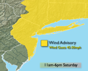
Scattered showers are possible this morning as an upper level low and its associated energy moves through. The sun will return later this morning and the wind will increase rapidly. A Wind Advisory has been issued for the entire tri-state area for West wind gusts of 45 to 50mph. The Winds will begin to diminish toward sunset.
Tonight will be clear and chilly as high pressure works in.
Sunday will be the better half of the weekend with abundant sunshine and seasonal readings.
The beginning of the workweek looks unsettled as the jet stream remains active and moisture moves up from the South. Another round of showers is expected Monday into Tuesday.
You know where to find a no hype, no nonsense forecast.
Stay tuned.
Today:
Spotty morning showers, otherwise becoming mostly sunny and windy. Highs around 60º temperatures falling through the 50s during the afternoon. West wind at 15-30mph with gusts to 45mph.
Tonight:
Clear and much colder than recent nights. Winds will diminish. Lows in the lower 40s in the City, the 30s inland. West wind diminishing to 5-10mph.
Sunday:
Sunny and seasonal. Highs in the mid 50s.
Monday:
Showers likely. Highs in the mid 50s.
Tuesday:
Mostly cloudy with spotty showers or areas of drizzle. Mild. Highs in the mid 60s.
Wednesday:
Partly sunny, breezy and mild. Highs in the mid 60s.
Keep it here for a no nonsense, no hype forecast.