Synopsis:
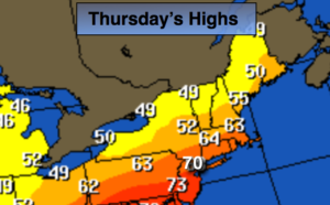
Our May-like conditions will continue for November’s debut. High pressure off the coast is a warm weather maker. In fact, some areas may hit 70º today as the high pumps up warm air from the South. A mix of sun and clouds is expected.
Showers are likely tonight and on Friday as a cool front approaches; it will be balmy. The latest computer guidance is now suggesting an area of low pressure will most likely develop Saturday night along the front over the Virginia piedmont and move North through the area on Saturday morning. Periods of rain will continue into Saturday morning. The sun will return during the afternoon along with a gusty wind.
Sunday will be the better half of the weekend.
You know where to find a no hype, no nonsense forecast.
Stay tuned.
Today:
Partly sunny. Warm. Highs in the 60s to around 70º. Southwest winds at 5-10mph.
Tonight:
Showers developing. Very warm. Temperatures will be higher then the average high for the date! Lows around 60º in the City, the 50s inland. Southwest winds at 8-12mph.
Friday:
Showers. Balmy.Highs in the upper 60s.
Saturday:
Chance of morning rain, otherwise becoming partly sunny and windy. Highs around 60º.
Sunday:
Sunny and seasonal. Highs in the mid 50s.
Monday:
Morning sun will give way to thickening clouds. Highs in the mid to upper 50s.
Keep it here for a no nonsense, no hype forecast.