Synopsis:
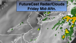
Our May-like conditions will continue through today. High pressure off the coast is the warm weather maker. Showers are likely today as a cool front approaches; it will be balmy. It’s looking like there will be several hours of dry time, so it doesn’t look like a washout.
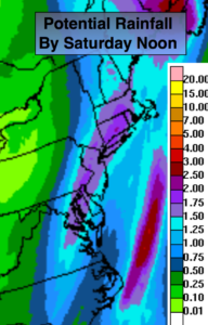
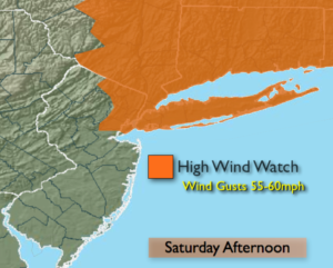
An area of low pressure will develop tonight along the front over the Virginia piedmont and move North through the area by Saturday morning. This will introduce a period of steady and possibly heavy rain tonight (potential rainfall map above). Once the front and low move off the coast some sun may return for a time on Saturday, but the threat of scattered showers will be with us as an upper low and energy moves through during the afternoon. The wind will increase rapidly by afternoon behind the front. A High Wind Watch has been issued for the NYC vicinity and to the North and East for possible Northwest wind gust up to 60mph (map above).
Sunday will be the better half of the weekend with abundant sunshine and seasonal readings.
The beginning of the workweek looks unsettled as the jet streams remains active and moisture moves up from the South.
You know where to find a no hype, no nonsense forecast.
Stay tuned.
Today:
On and off Showers. There will be several hours of dry time. Balmy. Highs in the upper 60s to lower 70s. Southwest to South winds at 10-15mph.
Tonight:
Rain, heavy at times. Very mild. Temperatures will be higher then the average high for the date! Lows in the upper 50s in the City, near 50º inland. South wind at 5-10mph.
Saturday:
Chance of morning rain, otherwise becoming partly sunny and windy. Scattered afternoon showers are possible. Highs around 60º.
Sunday:
Sunny and seasonal. Highs in the mid 50s.
Monday:
Mostly cloudy with scattered showers developing. Highs in the mid to upper 50s.
Tuesday:
Mostly cloudy with spotty showers. Mild. Highs in the mid 60s.
Keep it here for a no nonsense, no hype forecast.