Synopsis:
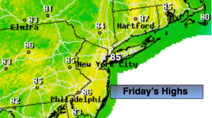
Today will be mostly sunny and comfortable as humidity levels will be low. A stray afternoon storm is possible, but most areas will be dry. A fine finish to the workweek.
This maybe one of the best August weekends we’ve experienced in some time. High pressure will dominate the Mid-Atlantic and Northeast. Abundant sunshine and low humidity is expected!
Keep it here for a no nonsense, no hype forecast.
Today:
Mostly sunny. Much lower humidity. A stray afternoon storm is possible. Highs in the mid 80s. West to Northwest winds at 8-12mph.
Tonight:
Clear and much cooler than recent nights. Lows in the 60s in urban areas, the upper 50s well inland. West to Northwest winds at 5-10mph.
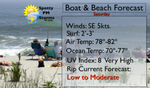
Saturday:
Sunny and comfortable. A top ten day. Highs in the lower 80s.
Sunday:
Sunny and comfortable. Another top ten day. Highs in the lower to mid 80s.
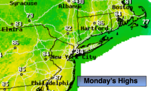
Monday:
Mostly sunny. Highs in the mid 80s.
Tuesday:
Hazy, warm and humid. Spotty PM Storms. Highs in the mid 80s.