Synopsis:
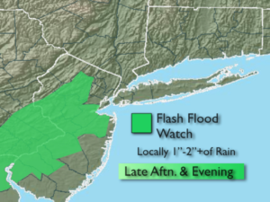
A Severe Thunderstorm Watch is up for the entire tri-state area through 8PM. A Flash Flood Watch is in effect for Morris, Hunterdon, Somerset, Middlesex, Mercer and Monmouth counties until 8PM. If you encounter a flooded roadway-TURN AROUND, DON’T DROWN.
Any showers and or storms will taper off later this evening.
Any clouds will give way to mainly sunny skies for Thursday- August’s debut. Friday will be seasonal with plenty of sun and right now the weekend looks decent as high pressure settles over the Northeast. There maybe isolated storms on Saturday but I wouldn’t cancel my outdoor plans.
Stay tuned.
Keep it here for a no nonsense, no hype forecast.
Tonight:
Scattered showers and storms this evening, otherwise partly cloudy and muggy. Lows in the lower 70s in the City, the 60s inland. Northwest winds at 5mph.
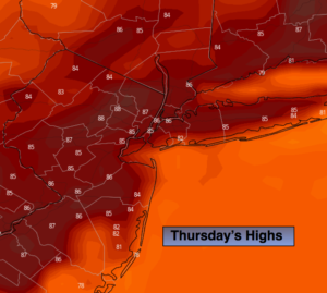
Thursday:
Early clouds to sun. Not as humid. Highs in the mid 80s. Northeast to Southeast winds at 5-10mph.
Friday:
Mostly sunny. Highs in the mid 80s.
Saturday:
Partly sunny and more humid. Isolated PM storms. Highs in the mid to upper 80s.
Sunday:
Mostly sunny. Highs in the upper 80s.
Monday:
Mostly sunny. Highs in the upper 80s.