Synopsis:
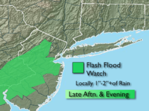
Today will be the best threat for afternoon and evening showers and storms. It’ll be hazy, warm and humid. Some of the storms may have torrential rain. The best bet for heavy rain looks to be in NJ. A Flash Flood Watch is in effect for Morris, Hunterdon, Somerset, Middlesex, Mercer and Monmouth counties into this evening. If you encounter a flooded roadway-TURN AROUND, DON’T DROWN.
Any showers and or storms will taper off later this evening.
Any clouds will give way to mainly sunny skies for Thursday- August’s debut. Friday will be seasonal with plenty of sun and right now the weekend looks decent.
Stay tuned.
Keep it here for a no nonsense, no hype forecast.
Today:
Hazy, warm and humid. Highs in the mid to upper 80s. Scattered afternoon and evening showers and storms. Southeast winds 5-10mph.
Tonight:
Scattered showers and storms this evening, otherwise partly cloudy and muggy. Lows in the lower 70s in the City, the 60s inland. Northwest winds at 5mph.
Thursday:
Early clouds to sun. Not as humid. Highs in the mid 80s.
Friday:
Mostly sunny. Highs in the mid 80s.
Saturday:
Partly sunny. Highs in the mid to upper 80s.
Sunday:
Mostly sunny. Highs in the upper 80s.