Synopsis:
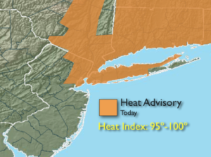
The heat will peak today. The combination of temperatures in the lower 90s and high humidity will make it feel like 95º-100º. A Heat Advisory is in effect for much of the NYC vicinity through this evening. A stray thunderstorm is possible later today and this evening mainly North and West of the City.
Tonight will be muggy under partly cloudy skies.
The best threat of showers and storms won’t arrive until Wednesday afternoon with a weak cool front. It’ll still be humid. A few spotty showers may linger into Thursday- August’s debut. Friday will be seasonal with plenty of sun and right now the weekend looks like a winner.
Stay tuned.
Keep it here for a no nonsense, no hype forecast.
Today:
Hazy, hot and humid. Highs in the lower 90s. Heat index: 95º-100º. Stray late day storm possible, mainly inland. Southwest winds 8-15mph.
Tonight:
An isolated evening storm inland, otherwise partly cloudy, muggy and warm. Lows in the mid to upper 70s in the City, the upper 60s inland. Southwest winds at 5mph.
Wednesday:
Hazy, very warm and humid. Scattered afternoon showers and storms. Highs in the mid to upper 80s.
Thursday:
Clouds, some sun. Scattered morning showers are possible. Highs in the mid 80s.
Friday:
Mostly sunny. Highs in the mid 80s.
Saturday:
Mostly sunny. Highs in the mid to upper 80s.
Sunday:
Mostly sunny. Highs in the upper 80s.