Synopsis:
The heat will stick around for the beginning of the workweek as a Southwesterly flow continues around offshore high pressure. The best threat of showers and storms won’t arrive until Wednesday afternoon with a weak cool front. A few spotty showers may linger into Thursday- August’s debut. Friday will be seasonal with plenty of sun.
Stay tuned.
Keep it here for a no nonsense, no hype forecast.
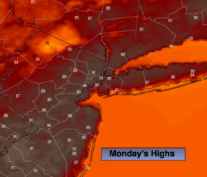
Today:
Hazy, hot and humid. Highs around 90º. Southwest winds at 8-12mph.
Tonight:
A spotty evening storm, otherwise partly cloudy and warm. Lows in the mid to upper 70s in the City. The upper 60s inland. Light Southwest winds.
Tuesday:
Hazy, hot and humid. Highs around 90º.
Wednesday:
Hazy, very warm and humid. Scattered afternoon showers and storms. Highs in the mid to upper 80s.
Thursday:
Clouds, some sun. Scattered showers are possible. Highs in the mid 80s.
Friday:
Sun and clouds. Highs in the mid 80s.