Synopsis:
The last weekend of July will be a winner. High pressure will dominate the Eastern one third of the country. Today, the hot word will be back as the high slips offshore and a Southwesterly flow takes over. You’ll notice a jump in the humidity as well.
A weak disturbance moving in from the Northwest may spark scattered showers and storms this evening.
The heat will stick around for the beginning of the workweek. The next threat of showers and storms won’t arrive until Wednesday afternoon.
Stay tuned.
Keep it here for a no nonsense, no hype forecast.
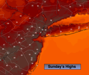
Today:
Hazy, hot and humid. Highs around 90º. Southwest winds at 8-12mph.
Tonight:
A spotty evening storm, otherwise partly cloudy and warm. Lows in the mid 70s in the City. The 60s inland. Light winds.
Monday:
Hazy, hot and humid. Highs around 90º.
Tuesday:
Hazy, hot and humid. Highs in the lower 90s.
Wednesday:
Hazy, very warm and humid. Scattered afternoon showers and storms. Highs in the mid to upper 80s.
Thursday:
Clouds, some sun. Scattered showers are possible. Highs in the mid 80s.