Synopsis:
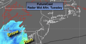
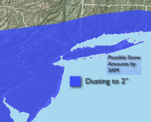
Low pressure will be developing over Eastern Virginia this evening. Light rain and or light wet snow will break out from Southwest to Northeast later in the afternoon and evening. Since the storm will be fast moving and just far enough offshore it doesn’t look like a big deal. A few hours of light snow is possible early tonight mainly by the coast. The potential is there for a dusting to up to 2″ of snow. The highest amounts are looking to be South and East of the City.
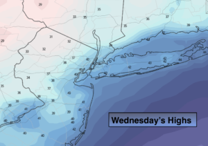
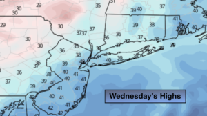
Wednesday will be windy and colder behind departing storm in Eastern Canada. Scattered snow squalls are possible during the afternoon. Any squall can reduce visibility to near zero and put a coating of snow on the ground within minutes. Please use caution and be aware of the rapidly changing weather conditions.
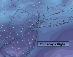
Thursday will be bright and seasonal. The average high temperatures are in the upper 30s.
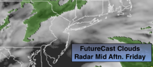
On Friday strong high pressure will move off the coast. A return Southwesterly flow will cause readings to pop into the 50s. In fact, readings will reach the Spring-like 60s both Saturday and Sunday. Spotty showers are possible on Saturday. Steadier rain is likely either Saturday night or Sunday morning with an approaching cool front.
It will be some time until we experience an Arctic blast or a decent snow event. Sorry snow lovers.
Stay Tuned.
Keep it here for a no hype, no nonsense forecast.
Tonight:
Rain or snow showers this evening. The potential is there for a couple of hours of snow for coastal areas later tonight. Lows around freezing in the City, the 20s inland. East to West winds at 5-10mph.
Wednesday:
Sun and clouds. Scattered afternoon snow squalls, windy and cold. Highs in the upper 30s. West to Northwest winds at 15-30mph with gusts to 40mph.
Thursday:
Sunny and seasonal. Highs in the mid to upper 30s.
Friday:
Sun and clouds. Much milder. Highs in the lower 50s.
Saturday:
Mostly cloudy and warm with spotty showers. Highs in the lower 60s.
Sunday:
Mostly cloudy and warm with a period of rain likely. Highs in the lower 60s.