Synopsis:
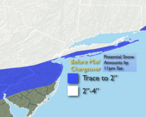
A couple of hours of steadier and heavier snow will occur this evening with the main push of precipitation moving in with a warm front. The snow will most likely change to rain along the coast, but inland snow or a snow/sleet mixture will continue. Accumulating snow will occur for much of the region this evening before the changeover. Coastal areas won’t see much of an accumulation. Above is the potential snowfall by 11PM tonight. Scattered showers or drizzle is likely late tonight was the warm front moves through.
Sunday will be windy and chilly under mix of clouds and some sun as the low moves East of Maine and strong high pressure settles over the Northern Plains.
Colder conditions will greet us through early week as extensive high pressure dominates the Eastern half of the country.
A warmup will occur late week as the high moves off the coast and a warmer Southwest flow develops.
Stay Tuned.
Keep it here for a no hype, no nonsense forecast.
Tonight:
A period of steadier and heavier snow this evening. Coastal and Southern areas will experience a change to sleet and rain. Scattered showers are expected late tonight for most of the area with areas of light sleet or snow well inland. Readings will rise into the lower 40s along the coast and to the South. Inland readings will rise through the 30s. Southwest to West winds at 5-10mph.
Sunday:
Clouds, some sun. Windy and chilly. Highs around 40º. West to Northwest winds at 15-25mph with higher gusts.
Martin Luther King Jr. Day:
Partly sunny. Cold. Highs around freezing.
Tuesday:
Partly sunny and cold. Highs near 30º.
Wednesday:
Sunny. Highs in the mid 30s.
Thursday:
Sunny. Milder. Highs in the mid 40s.