Synopsis:
A storm will develop over the Ohio Valley today and move into the Eastern Great Lakes. Normally, this would be a warm storm track with the system to the West, but Arctic high pressure will nose in from Eastern Canada and into the Northeast. The low’s warm front will be responsible for the precipitation. This will result in snow developing by Saturday afternoon. The snow will be light and intermittent through mid-afternoon. A couple of hours of steadier and heavier snow is likely around sunset. The snow will most likely change to rain along the coast by late day but inland snow or a snow/sleet mixture will continue. A secondary storm will form over Eastern New England. If this secondary storm formed farther South it would keep the cold air in place, but since it will develop later, warmer air will work in from off the Ocean.
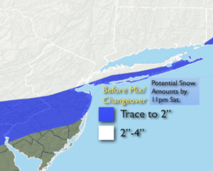
Accumulating snow will occur for much of the region later in the day and early this evening before the changeover. Coastal areas won’t see much of an accumulation. Above is the potential snowfall by late Saturday evening.
Light precipitation will continue into tonight with most areas seeing light rain or sleet.
Sunday will be windy and chilly under mix of clouds and some sun.
Colder conditions will greet us through midweek under mainly sunny skies.
No major storms are in sight.
Stay Tuned.
Keep it here for a no hype, no nonsense forecast.
Saturday:
Thickening clouds during the morning. Intermittent light snow developing around midday. The snow will change to rain along the coast. A couple of hours of steadier and heavier snow is possible around sunset for most of the area excluding coastal areas and to the South. Inland a mix of snow, sleet and rain will continue into the evening. Highs in the 30s, lower 40s at the coast. Southeast winds at 5-10mph.
Tonight:
Areas of light rain. Light mixed precipitation inland. Lows in the lower to mid 30s in the City, the around 30º inland. Southwest to West winds at 5-10mph.
Sunday:
Clouds, some sun. Windy and chilly. Highs around 40º.
Martin Luther King Jr. Day:
Partly sunny. Cold. Highs around freezing.
Tuesday:
Partly sunny and cold. Highs near 30º.
Wednesday:
Sunny. Highs in the mid 30s.