Synopsis:
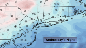
A cold front will toward the region tonight. Skies will become mostly cloudy. Scattered showers are likely late.
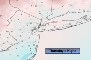
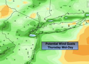
On Thursday morning the front will take any showers with it offshore. Skies will become mostly sunny and a strong Northwest wind will develop. Gusts between 40-50mph are likely.
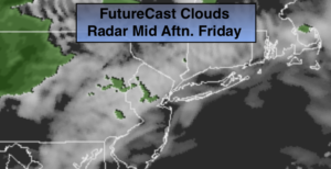
Arctic high pressure will influence our area on Friday. This will result in sunny but cold readings. Highs will only be near freezing.
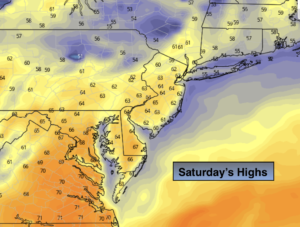
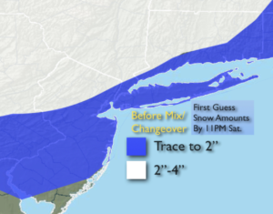
A storm will develop over the Ohio Valley on Saturday and move into the Eastern Great Lakes. Normally, this would be a warm storm track with the system to the West, but Arctic high pressure will nose in from Eastern Canada and into the Northeast. The low’s warm front will be responsible for the precipitation. This will result in snow developing by Saturday afternoon. The snow will most likely change to rain along the coast during the day but inland snow or a snow/sleet mixture will continue. A secondary storm will form over Eastern New England. If this secondary storm formed farther South it would keep the cold air in place, but since it will develop later, warmer air will work in from off the Ocean.
The potential of an accumulating snow exists later in the day Saturday before the changeover. Coastal areas won’t see much of an accumulation. Above is the first guess on the potential snowfall by late Saturday evening. These amounts are not etched in stone, but rather give a general idea of where the higher totals are possible. Once again, this is NOT a classic setup for a snowstorm.
Sunday will be windy and chilly under mix of clouds and some sun.
Much colder conditions will greet us for the beginning of the week.
Stay Tuned.
Keep it here for a no hype, no nonsense forecast.
Tonight:
Becoming mostly cloudy. Scattered showers possible late. Lows around 40º in the City, the 30s inland. South winds at 5-10mph.
Thursday:
An early morning shower east, otherwise mostly sunny. Becoming windy. Highs in the mid to upper 40s. Temperatures will fall during the afternoon. West to Northwest winds increasing to 15-30mph with gusts to 45mph.
Friday:
Sunny. Colder. Highs near freezing.
Saturday:
Thickening clouds during the morning. Snow developing by afternoon. The snow will change to rain along the coast. Inland a mix of snow, sleet and rain will continue into the evening. Highs in the 30s, lower 40s at the coast.
Sunday:
Clouds, some sun. Windy and chilly. Highs around 40º.
Monday:
Partly sunny with scattered flurries. Cold. Highs around freezing.