Synopsis:
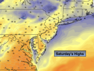
Spring-like readings and record warm temperatures are expected both today and Sunday as a Bermuda dominates the East coast. It’ll feel more like late April and early May then the dead of Winter. Spotty showers are possible today along with patchy fog but the majority of the day will be dry. Showers are likely by Sunday morning with an approaching cool front. The average high is 38º. The record high for today is 63º. The record high for tomorrow is 66º. These record temperatures are in jeopardy.
Even with a cool frontal passage on Monday readings will be almost ten degrees above average.
Tranquil conditions are expected through midweek.
It will be some time until we experience an Arctic blast or a decent snow event. The weather pattern is horrible for Winter conditions. Sorry snow lovers.
Stay Tuned.
Keep it here for a no hype, no nonsense forecast.
Today:
Mostly cloudy and warm with a spot shower. Highs in the mid 60s. South to Southwest winds at 10-15mph.
Tonight:
Cloudy with scattered showers. Balmy. Temperatures will remain in the 60s! Thats more than 35º above normal for nighttime lows! South to Southwest winds at 5-10mph.
Sunday:
Morning showers, otherwise becoming mostly sunny. Warm. Highs 65º-70º.
Monday:
Partly sunny. Highs around 50º.
Tuesday:
Sun to clouds. Highs in the mid 40s.
Wednesday:
Partly sunny. Highs in the lower 50s.